You are here: Home > Network List > TA - USArray Transportable Network (new EarthScope stations) Stations List
> Station J31A Geddes, SD, USA > Earthquake Result Viewer
J31A Geddes, SD, USA - Earthquake Result Viewer
| Earthquake location: |
Chile-Bolivia Border Region |
| Earthquake latitude/longitude: |
-21.7/-68.2 |
| Earthquake time(UTC): |
2011/06/20 (171) 16:36:01 GMT |
| Earthquake Depth: |
128 km |
| Earthquake Magnitude: |
6.0 MB, 6.5 MW, 6.5 MW |
| Earthquake Catalog/Contributor: |
WHDF/NEIC |
|
| Network: |
TA USArray Transportable Network (new EarthScope stations) |
| Station: |
J31A Geddes, SD, USA |
| Lat/Lon: |
43.29 N/98.74 W |
| Elevation: |
491 m |
|
| Distance: |
70.5 deg |
| Az: |
336.841 deg |
| Baz: |
149.941 deg |
| Ray Param: |
0.05460906 |
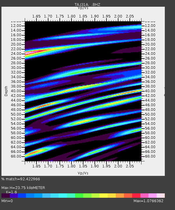
| Estimated Moho Depth: |
23.75 km |
| Estimated Crust Vp/Vs: |
1.60 |
| Assumed Crust Vp: |
6.53 km/s |
| Estimated Crust Vs: |
4.082 km/s |
| Estimated Crust Poisson's Ratio: |
0.18 |
|
| Radial Match: |
92.422966 % |
| Radial Bump: |
400 |
| Transverse Match: |
78.13852 % |
| Transverse Bump: |
400 |
| SOD ConfigId: |
395004 |
| Insert Time: |
2011-12-01 06:34:52.195 +0000 |
| GWidth: |
2.5 |
| Max Bumps: |
400 |
| Tol: |
0.001 |
|
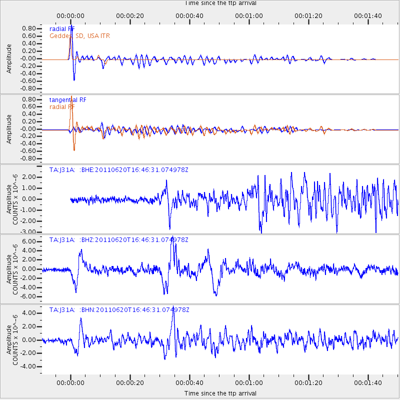
Signal To Noise
| Channel | StoN | STA | LTA |
| TA:J31A: :BHZ:20110620T16:46:31.074978Z | 10.63154 | 2.5198667E-6 | 2.3701803E-7 |
| TA:J31A: :BHN:20110620T16:46:31.074978Z | 7.876718 | 1.4501986E-6 | 1.8411204E-7 |
| TA:J31A: :BHE:20110620T16:46:31.074978Z | 6.491238 | 9.500794E-7 | 1.4636336E-7 |
| Arrivals |
| Ps | 2.3 SECOND |
| PpPs | 9.1 SECOND |
| PsPs/PpSs | 11 SECOND |


