You are here: Home > Network List > TA - USArray Transportable Network (new EarthScope stations) Stations List
> Station D32A Dogwood Acres, Gardner, ND, USA > Earthquake Result Viewer
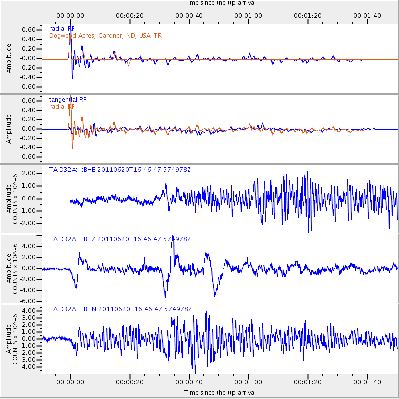
D32A Dogwood Acres, Gardner, ND, USA - Earthquake Result Viewer
*The percent match for this event was below the threshold and hence no stack was calculated.
| Earthquake location: |
Chile-Bolivia Border Region |
| Earthquake latitude/longitude: |
-21.7/-68.2 |
| Earthquake time(UTC): |
2011/06/20 (171) 16:36:01 GMT |
| Earthquake Depth: |
128 km |
| Earthquake Magnitude: |
6.0 MB, 6.5 MW, 6.5 MW |
| Earthquake Catalog/Contributor: |
WHDF/NEIC |
|
| Network: |
TA USArray Transportable Network (new EarthScope stations) |
| Station: |
D32A Dogwood Acres, Gardner, ND, USA |
| Lat/Lon: |
47.14 N/97.02 W |
| Elevation: |
280 m |
|
| Distance: |
73.3 deg |
| Az: |
339.921 deg |
| Baz: |
152.119 deg |
| Ray Param: |
$rayparam |
*The percent match for this event was below the threshold and hence was not used in the summary stack. |
|
| Radial Match: |
76.50463 % |
| Radial Bump: |
400 |
| Transverse Match: |
64.03366 % |
| Transverse Bump: |
400 |
| SOD ConfigId: |
395004 |
| Insert Time: |
2011-12-01 06:35:50.658 +0000 |
| GWidth: |
2.5 |
| Max Bumps: |
400 |
| Tol: |
0.001 |
|
Signal To Noise
| Channel | StoN | STA | LTA |
| TA:D32A: :BHZ:20110620T16:46:47.574978Z | 15.53556 | 1.769408E-6 | 1.1389406E-7 |
| TA:D32A: :BHN:20110620T16:46:47.574978Z | 5.638143 | 9.64402E-7 | 1.7104959E-7 |
| TA:D32A: :BHE:20110620T16:46:47.574978Z | 2.7572227 | 5.198797E-7 | 1.8855195E-7 |
| Arrivals |
| Ps | |
| PpPs | |
| PsPs/PpSs | |


