You are here: Home > Network List > TA - USArray Transportable Network (new EarthScope stations) Stations List
> Station C31A Landman Farms, Northwood, ND, USA > Earthquake Result Viewer
C31A Landman Farms, Northwood, ND, USA - Earthquake Result Viewer
| Earthquake location: |
Chile-Bolivia Border Region |
| Earthquake latitude/longitude: |
-21.7/-68.2 |
| Earthquake time(UTC): |
2011/06/20 (171) 16:36:01 GMT |
| Earthquake Depth: |
128 km |
| Earthquake Magnitude: |
6.0 MB, 6.5 MW, 6.5 MW |
| Earthquake Catalog/Contributor: |
WHDF/NEIC |
|
| Network: |
TA USArray Transportable Network (new EarthScope stations) |
| Station: |
C31A Landman Farms, Northwood, ND, USA |
| Lat/Lon: |
47.79 N/97.73 W |
| Elevation: |
384 m |
|
| Distance: |
74.1 deg |
| Az: |
339.798 deg |
| Baz: |
151.557 deg |
| Ray Param: |
0.052252524 |
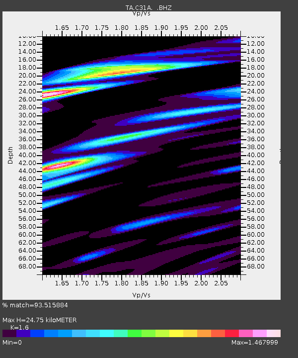
| Estimated Moho Depth: |
24.75 km |
| Estimated Crust Vp/Vs: |
1.60 |
| Assumed Crust Vp: |
6.498 km/s |
| Estimated Crust Vs: |
4.061 km/s |
| Estimated Crust Poisson's Ratio: |
0.18 |
|
| Radial Match: |
93.515884 % |
| Radial Bump: |
400 |
| Transverse Match: |
79.055824 % |
| Transverse Bump: |
400 |
| SOD ConfigId: |
395004 |
| Insert Time: |
2011-12-01 06:36:41.118 +0000 |
| GWidth: |
2.5 |
| Max Bumps: |
400 |
| Tol: |
0.001 |
|

Signal To Noise
| Channel | StoN | STA | LTA |
| TA:C31A: :BHZ:20110620T16:46:52.27499Z | 14.215858 | 1.7543452E-6 | 1.2340762E-7 |
| TA:C31A: :BHN:20110620T16:46:52.27499Z | 5.897377 | 9.2834244E-7 | 1.5741615E-7 |
| TA:C31A: :BHE:20110620T16:46:52.27499Z | 5.491033 | 7.4523876E-7 | 1.3571922E-7 |
| Arrivals |
| Ps | 2.4 SECOND |
| PpPs | 9.5 SECOND |
| PsPs/PpSs | 12 SECOND |


