You are here: Home > Network List > TA - USArray Transportable Network (new EarthScope stations) Stations List
> Station J37A Redenius Farm, Forest, IA, USA > Earthquake Result Viewer
J37A Redenius Farm, Forest, IA, USA - Earthquake Result Viewer

| Earthquake location: |
Chile-Bolivia Border Region |
| Earthquake latitude/longitude: |
-21.7/-68.2 |
| Earthquake time(UTC): |
2011/06/20 (171) 16:36:01 GMT |
| Earthquake Depth: |
128 km |
| Earthquake Magnitude: |
6.0 MB, 6.5 MW, 6.5 MW |
| Earthquake Catalog/Contributor: |
WHDF/NEIC |
|
| Network: |
TA USArray Transportable Network (new EarthScope stations) |
| Station: |
J37A Redenius Farm, Forest, IA, USA |
| Lat/Lon: |
43.31 N/93.55 W |
| Elevation: |
385 m |
|
| Distance: |
68.8 deg |
| Az: |
340.428 deg |
| Baz: |
154.736 deg |
| Ray Param: |
0.055756688 |
| Estimated Moho Depth: |
45.25 km |
| Estimated Crust Vp/Vs: |
1.68 |
| Assumed Crust Vp: |
6.53 km/s |
| Estimated Crust Vs: |
3.887 km/s |
| Estimated Crust Poisson's Ratio: |
0.23 |
|
| Radial Match: |
95.4784 % |
| Radial Bump: |
400 |
| Transverse Match: |
85.52049 % |
| Transverse Bump: |
400 |
| SOD ConfigId: |
395004 |
| Insert Time: |
2011-12-01 06:39:47.915 +0000 |
| GWidth: |
2.5 |
| Max Bumps: |
400 |
| Tol: |
0.001 |
|
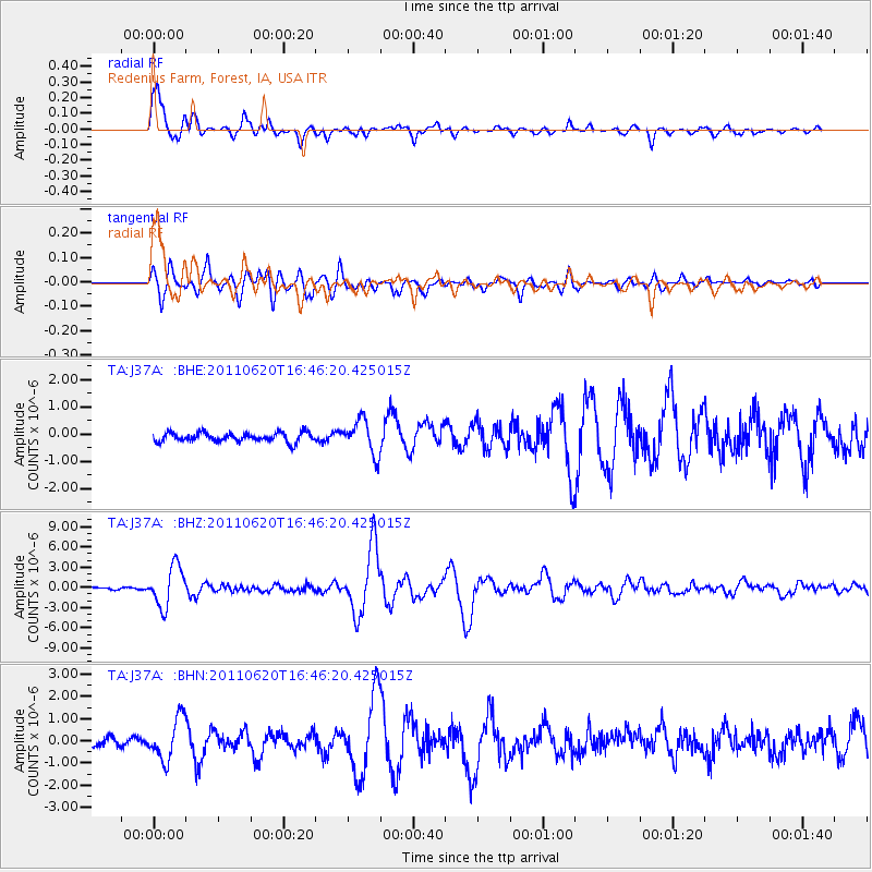
Signal To Noise
| Channel | StoN | STA | LTA |
| TA:J37A: :BHZ:20110620T16:46:20.425015Z | 20.271914 | 2.9745281E-6 | 1.467315E-7 |
| TA:J37A: :BHN:20110620T16:46:20.425015Z | 5.1233253 | 9.4145884E-7 | 1.8375933E-7 |
| TA:J37A: :BHE:20110620T16:46:20.425015Z | 3.7693975 | 6.303175E-7 | 1.6721968E-7 |
| Arrivals |
| Ps | 4.9 SECOND |
| PpPs | 18 SECOND |
| PsPs/PpSs | 23 SECOND |


