You are here: Home > Network List > TA - USArray Transportable Network (new EarthScope stations) Stations List
> Station J36A Seneca 1, Swea City, IA, USA > Earthquake Result Viewer
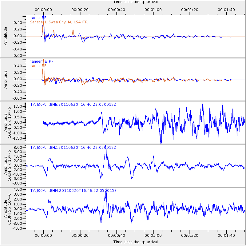
J36A Seneca 1, Swea City, IA, USA - Earthquake Result Viewer

| Earthquake location: |
Chile-Bolivia Border Region |
| Earthquake latitude/longitude: |
-21.7/-68.2 |
| Earthquake time(UTC): |
2011/06/20 (171) 16:36:01 GMT |
| Earthquake Depth: |
128 km |
| Earthquake Magnitude: |
6.0 MB, 6.5 MW, 6.5 MW |
| Earthquake Catalog/Contributor: |
WHDF/NEIC |
|
| Network: |
TA USArray Transportable Network (new EarthScope stations) |
| Station: |
J36A Seneca 1, Swea City, IA, USA |
| Lat/Lon: |
43.33 N/94.34 W |
| Elevation: |
370 m |
|
| Distance: |
69.0 deg |
| Az: |
339.882 deg |
| Baz: |
154.001 deg |
| Ray Param: |
0.05558204 |
| Estimated Moho Depth: |
39.75 km |
| Estimated Crust Vp/Vs: |
1.89 |
| Assumed Crust Vp: |
6.53 km/s |
| Estimated Crust Vs: |
3.46 km/s |
| Estimated Crust Poisson's Ratio: |
0.30 |
|
| Radial Match: |
95.16946 % |
| Radial Bump: |
400 |
| Transverse Match: |
83.63167 % |
| Transverse Bump: |
400 |
| SOD ConfigId: |
395004 |
| Insert Time: |
2011-12-01 06:40:01.468 +0000 |
| GWidth: |
2.5 |
| Max Bumps: |
400 |
| Tol: |
0.001 |
|
Signal To Noise
| Channel | StoN | STA | LTA |
| TA:J36A: :BHZ:20110620T16:46:22.050015Z | 26.412905 | 2.4265119E-6 | 9.186843E-8 |
| TA:J36A: :BHN:20110620T16:46:22.050015Z | 8.732112 | 1.0723245E-6 | 1.2280242E-7 |
| TA:J36A: :BHE:20110620T16:46:22.050015Z | 6.6954722 | 5.5116266E-7 | 8.2318714E-8 |
| Arrivals |
| Ps | 5.6 SECOND |
| PpPs | 17 SECOND |
| PsPs/PpSs | 23 SECOND |


