You are here: Home > Network List > TA - USArray Transportable Network (new EarthScope stations) Stations List
> Station I37A Lemond, Waseca, MN, USA > Earthquake Result Viewer
I37A Lemond, Waseca, MN, USA - Earthquake Result Viewer

| Earthquake location: |
Chile-Bolivia Border Region |
| Earthquake latitude/longitude: |
-21.7/-68.2 |
| Earthquake time(UTC): |
2011/06/20 (171) 16:36:01 GMT |
| Earthquake Depth: |
128 km |
| Earthquake Magnitude: |
6.0 MB, 6.5 MW, 6.5 MW |
| Earthquake Catalog/Contributor: |
WHDF/NEIC |
|
| Network: |
TA USArray Transportable Network (new EarthScope stations) |
| Station: |
I37A Lemond, Waseca, MN, USA |
| Lat/Lon: |
44.01 N/93.40 W |
| Elevation: |
371 m |
|
| Distance: |
69.3 deg |
| Az: |
340.855 deg |
| Baz: |
154.993 deg |
| Ray Param: |
0.055366635 |
| Estimated Moho Depth: |
40.5 km |
| Estimated Crust Vp/Vs: |
2.10 |
| Assumed Crust Vp: |
6.571 km/s |
| Estimated Crust Vs: |
3.133 km/s |
| Estimated Crust Poisson's Ratio: |
0.35 |
|
| Radial Match: |
93.42093 % |
| Radial Bump: |
400 |
| Transverse Match: |
79.48099 % |
| Transverse Bump: |
400 |
| SOD ConfigId: |
395004 |
| Insert Time: |
2011-12-01 06:40:23.798 +0000 |
| GWidth: |
2.5 |
| Max Bumps: |
400 |
| Tol: |
0.001 |
|
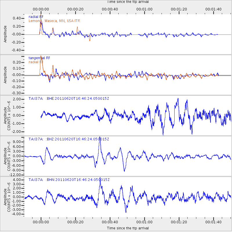
Signal To Noise
| Channel | StoN | STA | LTA |
| TA:I37A: :BHZ:20110620T16:46:24.050015Z | 15.354698 | 3.3232336E-6 | 2.1643106E-7 |
| TA:I37A: :BHN:20110620T16:46:24.050015Z | 5.240489 | 9.809381E-7 | 1.8718447E-7 |
| TA:I37A: :BHE:20110620T16:46:24.050015Z | 1.5100065 | 3.9541908E-7 | 2.618658E-7 |
| Arrivals |
| Ps | 7.0 SECOND |
| PpPs | 18 SECOND |
| PsPs/PpSs | 25 SECOND |


