You are here: Home > Network List > TA - USArray Transportable Network (new EarthScope stations) Stations List
> Station K36A Gilmore City, IA, USA > Earthquake Result Viewer
K36A Gilmore City, IA, USA - Earthquake Result Viewer
| Earthquake location: |
Chile-Bolivia Border Region |
| Earthquake latitude/longitude: |
-21.7/-68.2 |
| Earthquake time(UTC): |
2011/06/20 (171) 16:36:01 GMT |
| Earthquake Depth: |
128 km |
| Earthquake Magnitude: |
6.0 MB, 6.5 MW, 6.5 MW |
| Earthquake Catalog/Contributor: |
WHDF/NEIC |
|
| Network: |
TA USArray Transportable Network (new EarthScope stations) |
| Station: |
K36A Gilmore City, IA, USA |
| Lat/Lon: |
42.64 N/94.45 W |
| Elevation: |
364 m |
|
| Distance: |
68.4 deg |
| Az: |
339.477 deg |
| Baz: |
153.779 deg |
| Ray Param: |
0.055964418 |
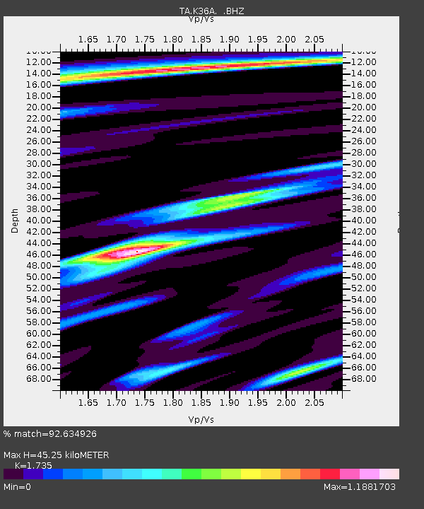
| Estimated Moho Depth: |
45.25 km |
| Estimated Crust Vp/Vs: |
1.74 |
| Assumed Crust Vp: |
6.53 km/s |
| Estimated Crust Vs: |
3.764 km/s |
| Estimated Crust Poisson's Ratio: |
0.25 |
|
| Radial Match: |
92.634926 % |
| Radial Bump: |
400 |
| Transverse Match: |
79.12648 % |
| Transverse Bump: |
400 |
| SOD ConfigId: |
395004 |
| Insert Time: |
2011-12-01 06:40:40.671 +0000 |
| GWidth: |
2.5 |
| Max Bumps: |
400 |
| Tol: |
0.001 |
|

Signal To Noise
| Channel | StoN | STA | LTA |
| TA:K36A: :BHZ:20110620T16:46:18.449978Z | 20.069847 | 2.8754E-6 | 1.4326966E-7 |
| TA:K36A: :BHN:20110620T16:46:18.449978Z | 6.449037 | 1.2917244E-6 | 2.0029725E-7 |
| TA:K36A: :BHE:20110620T16:46:18.449978Z | 5.307801 | 5.988735E-7 | 1.1282893E-7 |
| Arrivals |
| Ps | 5.3 SECOND |
| PpPs | 18 SECOND |
| PsPs/PpSs | 24 SECOND |


