You are here: Home > Network List > TA - USArray Transportable Network (new EarthScope stations) Stations List
> Station F32A Veblen, SD, USA > Earthquake Result Viewer
F32A Veblen, SD, USA - Earthquake Result Viewer
| Earthquake location: |
Chile-Bolivia Border Region |
| Earthquake latitude/longitude: |
-21.7/-68.2 |
| Earthquake time(UTC): |
2011/06/20 (171) 16:36:01 GMT |
| Earthquake Depth: |
128 km |
| Earthquake Magnitude: |
6.0 MB, 6.5 MW, 6.5 MW |
| Earthquake Catalog/Contributor: |
WHDF/NEIC |
|
| Network: |
TA USArray Transportable Network (new EarthScope stations) |
| Station: |
F32A Veblen, SD, USA |
| Lat/Lon: |
45.87 N/97.13 W |
| Elevation: |
371 m |
|
| Distance: |
72.2 deg |
| Az: |
339.229 deg |
| Baz: |
151.833 deg |
| Ray Param: |
0.053500406 |
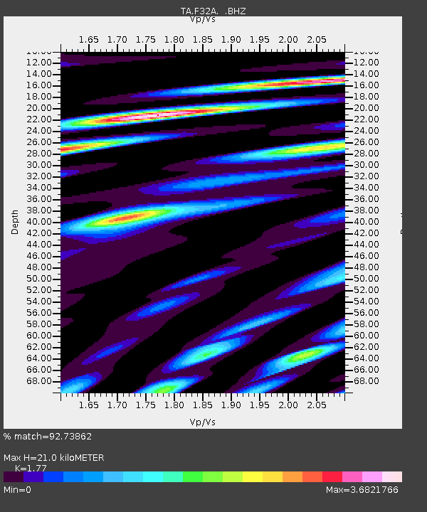
| Estimated Moho Depth: |
21.0 km |
| Estimated Crust Vp/Vs: |
1.77 |
| Assumed Crust Vp: |
6.552 km/s |
| Estimated Crust Vs: |
3.702 km/s |
| Estimated Crust Poisson's Ratio: |
0.27 |
|
| Radial Match: |
92.73862 % |
| Radial Bump: |
400 |
| Transverse Match: |
79.46969 % |
| Transverse Bump: |
400 |
| SOD ConfigId: |
395004 |
| Insert Time: |
2011-12-01 06:41:48.614 +0000 |
| GWidth: |
2.5 |
| Max Bumps: |
400 |
| Tol: |
0.001 |
|
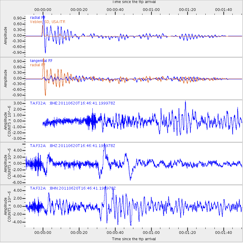
Signal To Noise
| Channel | StoN | STA | LTA |
| TA:F32A: :BHZ:20110620T16:46:41.199978Z | 3.140693 | 1.939416E-6 | 6.1751217E-7 |
| TA:F32A: :BHN:20110620T16:46:41.199978Z | 3.2695894 | 1.4422906E-6 | 4.4112286E-7 |
| TA:F32A: :BHE:20110620T16:46:41.199978Z | 2.0411122 | 7.0997123E-7 | 3.4783548E-7 |
| Arrivals |
| Ps | 2.6 SECOND |
| PpPs | 8.6 SECOND |
| PsPs/PpSs | 11 SECOND |


