You are here: Home > Network List > TA - USArray Transportable Network (new EarthScope stations) Stations List
> Station N37A Lee Faris, Mount Ayr, IA, USA > Earthquake Result Viewer
N37A Lee Faris, Mount Ayr, IA, USA - Earthquake Result Viewer
| Earthquake location: |
Chile-Bolivia Border Region |
| Earthquake latitude/longitude: |
-21.7/-68.2 |
| Earthquake time(UTC): |
2011/06/20 (171) 16:36:01 GMT |
| Earthquake Depth: |
128 km |
| Earthquake Magnitude: |
6.0 MB, 6.5 MW, 6.5 MW |
| Earthquake Catalog/Contributor: |
WHDF/NEIC |
|
| Network: |
TA USArray Transportable Network (new EarthScope stations) |
| Station: |
N37A Lee Faris, Mount Ayr, IA, USA |
| Lat/Lon: |
40.76 N/94.21 W |
| Elevation: |
351 m |
|
| Distance: |
66.7 deg |
| Az: |
338.752 deg |
| Baz: |
153.662 deg |
| Ray Param: |
0.057107784 |
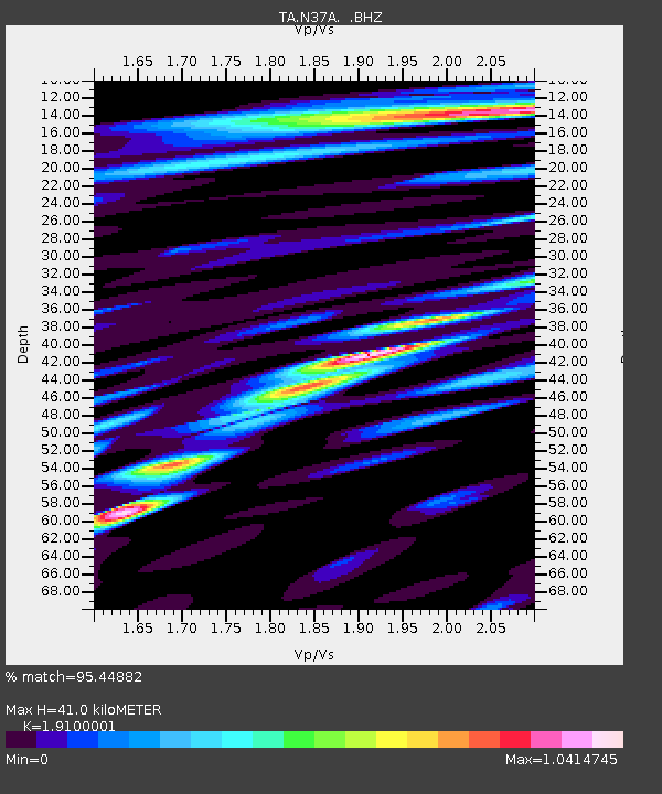
| Estimated Moho Depth: |
41.0 km |
| Estimated Crust Vp/Vs: |
1.91 |
| Assumed Crust Vp: |
6.498 km/s |
| Estimated Crust Vs: |
3.402 km/s |
| Estimated Crust Poisson's Ratio: |
0.31 |
|
| Radial Match: |
95.44882 % |
| Radial Bump: |
400 |
| Transverse Match: |
74.45485 % |
| Transverse Bump: |
400 |
| SOD ConfigId: |
395004 |
| Insert Time: |
2011-12-01 06:41:52.867 +0000 |
| GWidth: |
2.5 |
| Max Bumps: |
400 |
| Tol: |
0.001 |
|

Signal To Noise
| Channel | StoN | STA | LTA |
| TA:N37A: :BHZ:20110620T16:46:07.39999Z | 31.067415 | 3.7860164E-6 | 1.2186453E-7 |
| TA:N37A: :BHN:20110620T16:46:07.39999Z | 11.249569 | 1.8395419E-6 | 1.6352111E-7 |
| TA:N37A: :BHE:20110620T16:46:07.39999Z | 4.39587 | 1.004939E-6 | 2.286098E-7 |
| Arrivals |
| Ps | 6.0 SECOND |
| PpPs | 18 SECOND |
| PsPs/PpSs | 24 SECOND |


