You are here: Home > Network List > TA - USArray Transportable Network (new EarthScope stations) Stations List
> Station O38A Galt, MO, USA > Earthquake Result Viewer
O38A Galt, MO, USA - Earthquake Result Viewer
| Earthquake location: |
Chile-Bolivia Border Region |
| Earthquake latitude/longitude: |
-21.7/-68.2 |
| Earthquake time(UTC): |
2011/06/20 (171) 16:36:01 GMT |
| Earthquake Depth: |
128 km |
| Earthquake Magnitude: |
6.0 MB, 6.5 MW, 6.5 MW |
| Earthquake Catalog/Contributor: |
WHDF/NEIC |
|
| Network: |
TA USArray Transportable Network (new EarthScope stations) |
| Station: |
O38A Galt, MO, USA |
| Lat/Lon: |
40.12 N/93.47 W |
| Elevation: |
266 m |
|
| Distance: |
65.9 deg |
| Az: |
338.999 deg |
| Baz: |
154.237 deg |
| Ray Param: |
0.057645254 |
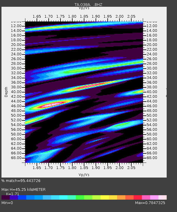
| Estimated Moho Depth: |
45.25 km |
| Estimated Crust Vp/Vs: |
1.71 |
| Assumed Crust Vp: |
6.498 km/s |
| Estimated Crust Vs: |
3.8 km/s |
| Estimated Crust Poisson's Ratio: |
0.24 |
|
| Radial Match: |
95.443726 % |
| Radial Bump: |
400 |
| Transverse Match: |
77.03115 % |
| Transverse Bump: |
400 |
| SOD ConfigId: |
395004 |
| Insert Time: |
2011-12-01 06:43:39.750 +0000 |
| GWidth: |
2.5 |
| Max Bumps: |
400 |
| Tol: |
0.001 |
|

Signal To Noise
| Channel | StoN | STA | LTA |
| TA:O38A: :BHZ:20110620T16:46:02.199978Z | 37.344204 | 3.1847078E-6 | 8.5279844E-8 |
| TA:O38A: :BHN:20110620T16:46:02.199978Z | 11.21532 | 1.6426543E-6 | 1.4646523E-7 |
| TA:O38A: :BHE:20110620T16:46:02.199978Z | 8.37655 | 9.188275E-7 | 1.09690454E-7 |
| Arrivals |
| Ps | 5.2 SECOND |
| PpPs | 18 SECOND |
| PsPs/PpSs | 23 SECOND |


