You are here: Home > Network List > TA - USArray Transportable Network (new EarthScope stations) Stations List
> Station P37A Lathrop, MO, USA > Earthquake Result Viewer
P37A Lathrop, MO, USA - Earthquake Result Viewer
| Earthquake location: |
Chile-Bolivia Border Region |
| Earthquake latitude/longitude: |
-21.7/-68.2 |
| Earthquake time(UTC): |
2011/06/20 (171) 16:36:01 GMT |
| Earthquake Depth: |
128 km |
| Earthquake Magnitude: |
6.0 MB, 6.5 MW, 6.5 MW |
| Earthquake Catalog/Contributor: |
WHDF/NEIC |
|
| Network: |
TA USArray Transportable Network (new EarthScope stations) |
| Station: |
P37A Lathrop, MO, USA |
| Lat/Lon: |
39.59 N/94.35 W |
| Elevation: |
300 m |
|
| Distance: |
65.7 deg |
| Az: |
338.077 deg |
| Baz: |
153.3 deg |
| Ray Param: |
0.057761926 |
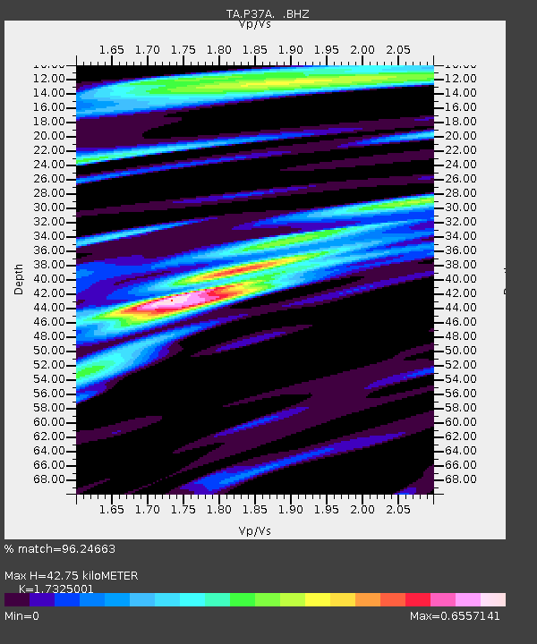
| Estimated Moho Depth: |
42.75 km |
| Estimated Crust Vp/Vs: |
1.73 |
| Assumed Crust Vp: |
6.498 km/s |
| Estimated Crust Vs: |
3.75 km/s |
| Estimated Crust Poisson's Ratio: |
0.25 |
|
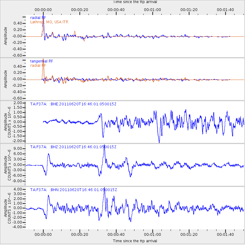
| Radial Match: |
96.24663 % |
| Radial Bump: |
400 |
| Transverse Match: |
82.75937 % |
| Transverse Bump: |
400 |
| SOD ConfigId: |
395004 |
| Insert Time: |
2011-12-01 06:43:54.217 +0000 |
| GWidth: |
2.5 |
| Max Bumps: |
400 |
| Tol: |
0.001 |
|
Signal To Noise
| Channel | StoN | STA | LTA |
| TA:P37A: :BHZ:20110620T16:46:01.050015Z | 23.621407 | 3.357964E-6 | 1.4215766E-7 |
| TA:P37A: :BHN:20110620T16:46:01.050015Z | 10.642599 | 1.3619284E-6 | 1.2796954E-7 |
| TA:P37A: :BHE:20110620T16:46:01.050015Z | 6.743119 | 6.860328E-7 | 1.0173821E-7 |
| Arrivals |
| Ps | 5.0 SECOND |
| PpPs | 17 SECOND |
| PsPs/PpSs | 22 SECOND |


