You are here: Home > Network List > G - GEOSCOPE Stations List
> Station AIS New Amsterdam, Indian Ocean > Earthquake Result Viewer
AIS New Amsterdam, Indian Ocean - Earthquake Result Viewer
| Earthquake location: |
Southern Sumatra, Indonesia |
| Earthquake latitude/longitude: |
-4.6/102.1 |
| Earthquake time(UTC): |
2000/06/04 (156) 16:39:45 GMT |
| Earthquake Depth: |
33 km |
| Earthquake Magnitude: |
6.7 MB |
| Earthquake Catalog/Contributor: |
WHDF/NEIC |
|
| Network: |
G GEOSCOPE |
| Station: |
AIS New Amsterdam, Indian Ocean |
| Lat/Lon: |
37.80 S/77.57 E |
| Elevation: |
35 m |
|
| Distance: |
39.9 deg |
| Az: |
210.866 deg |
| Baz: |
40.205 deg |
| Ray Param: |
0.07465925 |
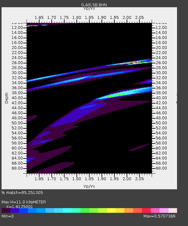
| Estimated Moho Depth: |
11.0 km |
| Estimated Crust Vp/Vs: |
1.61 |
| Assumed Crust Vp: |
4.802 km/s |
| Estimated Crust Vs: |
2.978 km/s |
| Estimated Crust Poisson's Ratio: |
0.19 |
|
| Radial Match: |
95.251305 % |
| Radial Bump: |
342 |
| Transverse Match: |
43.741344 % |
| Transverse Bump: |
400 |
| SOD ConfigId: |
3744 |
| Insert Time: |
2010-02-26 21:25:16.589 +0000 |
| GWidth: |
2.5 |
| Max Bumps: |
400 |
| Tol: |
0.001 |
|
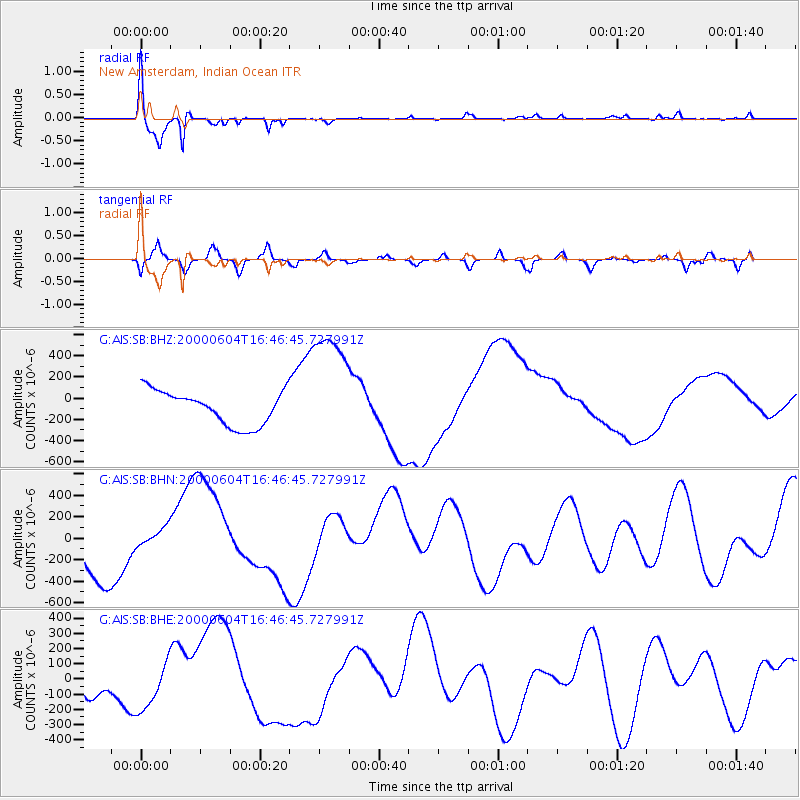
Signal To Noise
| Channel | StoN | STA | LTA |
| G:AIS:SB:BHN:20000604T16:46:45.727991Z | 0.4625381 | 8.96061E-5 | 1.9372696E-4 |
| G:AIS:SB:BHE:20000604T16:46:45.727991Z | 1.4153175 | 1.5993927E-4 | 1.13005925E-4 |
| G:AIS:SB:BHZ:20000604T16:46:45.727991Z | 3.611105 | 5.7873037E-4 | 1.6026407E-4 |
| Arrivals |
| Ps | 1.5 SECOND |
| PpPs | 5.7 SECOND |
| PsPs/PpSs | 7.2 SECOND |


