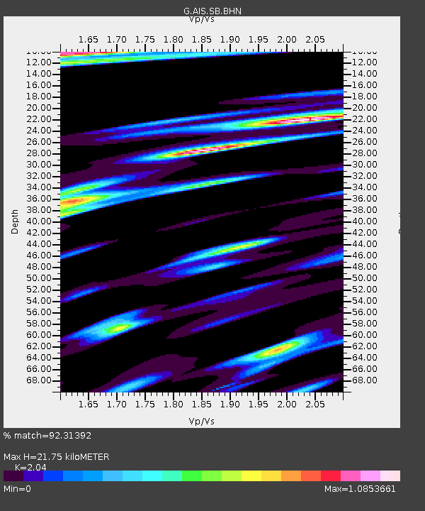
AIS New Amsterdam, Indian Ocean - Earthquake Result Viewer
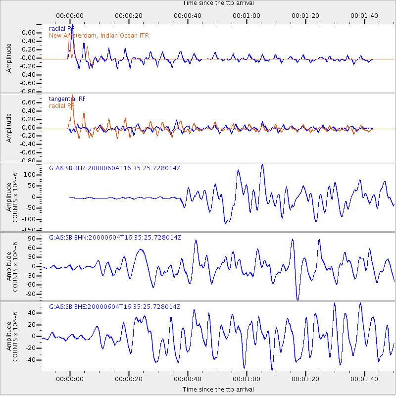
Earthquake location: Southern Sumatra, Indonesia
Earthquake latitude/longitude: -4.7/102.1
Earthquake time(UTC): 2000/06/04 (156) 16:28:26 GMT
Earthquake Depth: 33 km
Earthquake Magnitude: 6.8 MB, 8.0 MS, 7.9 MW, 7.7 MW
Earthquake Catalog/Contributor: WHDF/NEIC
Network: G GEOSCOPE
Station: AIS New Amsterdam, Indian Ocean
Lat/Lon: 37.80 S/77.57 E
Elevation: 35 m
Distance: 39.8 deg
Az: 210.898 deg
Baz: 40.245 deg
Ray Param: 0.07470346
Estimated Moho Depth: 21.75 km
Estimated Crust Vp/Vs: 2.04
Assumed Crust Vp: 4.802 km/s
Estimated Crust Vs: 2.354 km/s
Estimated Crust Poisson's Ratio: 0.34
Radial Match: 92.31392 %
Radial Bump: 313
Transverse Match: 67.39307 %
Transverse Bump: 400
SOD ConfigId: 3744
Insert Time: 2010-02-26 21:25:21.564 +0000
GWidth: 2.5
Max Bumps: 400
Tol: 0.001

Signal To Noise

ChannelStoNSTALTA
G:AIS:SB:BHN:20000604T16:35:25.728014Z1.43145324.6417204E-63.242663E-6
G:AIS:SB:BHE:20000604T16:35:25.728014Z0.56541592.5234665E-64.463027E-6
G:AIS:SB:BHZ:20000604T16:35:25.728014Z1.28797222.899356E-62.2511015E-6
Arrivals
Ps4.9 SECOND
PpPs13 SECOND
PsPs/PpSs18 SECOND