You are here: Home > Network List > G - GEOSCOPE Stations List
> Station AIS New Amsterdam, Indian Ocean > Earthquake Result Viewer
AIS New Amsterdam, Indian Ocean - Earthquake Result Viewer

| Earthquake location: |
Kermadec Islands Region |
| Earthquake latitude/longitude: |
-27.9/-178.4 |
| Earthquake time(UTC): |
2000/04/11 (102) 06:41:26 GMT |
| Earthquake Depth: |
201 km |
| Earthquake Magnitude: |
5.6 MB, 5.9 MW, 5.8 MW |
| Earthquake Catalog/Contributor: |
WHDF/NEIC |
|
| Network: |
G GEOSCOPE |
| Station: |
AIS New Amsterdam, Indian Ocean |
| Lat/Lon: |
37.80 S/77.57 E |
| Elevation: |
35 m |
|
| Distance: |
83.4 deg |
| Az: |
230.676 deg |
| Baz: |
120.239 deg |
| Ray Param: |
0.04570669 |
| Estimated Moho Depth: |
64.0 km |
| Estimated Crust Vp/Vs: |
1.67 |
| Assumed Crust Vp: |
4.802 km/s |
| Estimated Crust Vs: |
2.871 km/s |
| Estimated Crust Poisson's Ratio: |
0.22 |
|
| Radial Match: |
97.912285 % |
| Radial Bump: |
87 |
| Transverse Match: |
96.40392 % |
| Transverse Bump: |
134 |
| SOD ConfigId: |
3753 |
| Insert Time: |
2010-02-26 21:25:22.903 +0000 |
| GWidth: |
2.5 |
| Max Bumps: |
400 |
| Tol: |
0.001 |
|
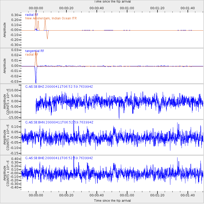
Signal To Noise
| Channel | StoN | STA | LTA |
| G:AIS:SB:BHN:20000411T06:52:59.763994Z | 0.93847877 | 3.775826E-8 | 4.023347E-8 |
| G:AIS:SB:BHE:20000411T06:52:59.763994Z | 0.94459575 | 1.047329E-7 | 1.10875895E-7 |
| G:AIS:SB:BHZ:20000411T06:52:59.763994Z | 0.9223683 | 3.3172657E-6 | 3.5964656E-6 |
| Arrivals |
| Ps | 9.1 SECOND |
| PpPs | 35 SECOND |
| PsPs/PpSs | 44 SECOND |


