You are here: Home > Network List > TA - USArray Transportable Network (new EarthScope stations) Stations List
> Station 240A Hunter Patterson, Mansfield, LA, USA > Earthquake Result Viewer
240A Hunter Patterson, Mansfield, LA, USA - Earthquake Result Viewer
| Earthquake location: |
Chile-Bolivia Border Region |
| Earthquake latitude/longitude: |
-21.7/-68.2 |
| Earthquake time(UTC): |
2011/06/20 (171) 16:36:01 GMT |
| Earthquake Depth: |
128 km |
| Earthquake Magnitude: |
6.0 MB, 6.5 MW, 6.5 MW |
| Earthquake Catalog/Contributor: |
WHDF/NEIC |
|
| Network: |
TA USArray Transportable Network (new EarthScope stations) |
| Station: |
240A Hunter Patterson, Mansfield, LA, USA |
| Lat/Lon: |
32.04 N/93.76 W |
| Elevation: |
119 m |
|
| Distance: |
58.8 deg |
| Az: |
334.649 deg |
| Baz: |
152.041 deg |
| Ray Param: |
0.062242452 |
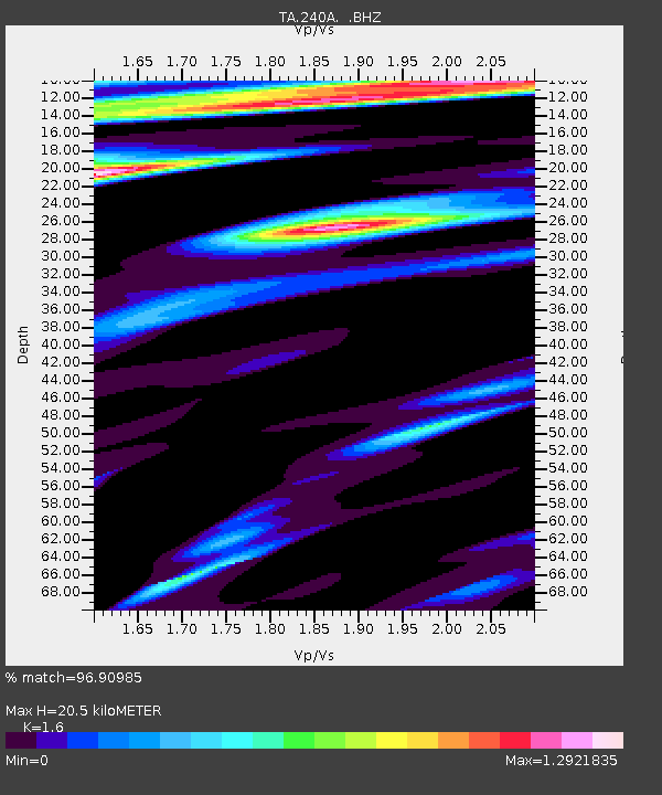
| Estimated Moho Depth: |
20.5 km |
| Estimated Crust Vp/Vs: |
1.60 |
| Assumed Crust Vp: |
6.245 km/s |
| Estimated Crust Vs: |
3.903 km/s |
| Estimated Crust Poisson's Ratio: |
0.18 |
|
| Radial Match: |
96.90985 % |
| Radial Bump: |
259 |
| Transverse Match: |
94.55481 % |
| Transverse Bump: |
377 |
| SOD ConfigId: |
395004 |
| Insert Time: |
2011-12-01 06:46:45.123 +0000 |
| GWidth: |
2.5 |
| Max Bumps: |
400 |
| Tol: |
0.001 |
|

Signal To Noise
| Channel | StoN | STA | LTA |
| TA:240A: :BHZ:20110620T16:45:15.074978Z | 33.998226 | 7.4476134E-6 | 2.1905889E-7 |
| TA:240A: :BHN:20110620T16:45:15.074978Z | 5.8648996 | 2.2269273E-6 | 3.7970426E-7 |
| TA:240A: :BHE:20110620T16:45:15.074978Z | 2.906021 | 9.663651E-7 | 3.325389E-7 |
| Arrivals |
| Ps | 2.1 SECOND |
| PpPs | 8.1 SECOND |
| PsPs/PpSs | 10 SECOND |


