You are here: Home > Network List > TA - USArray Transportable Network (new EarthScope stations) Stations List
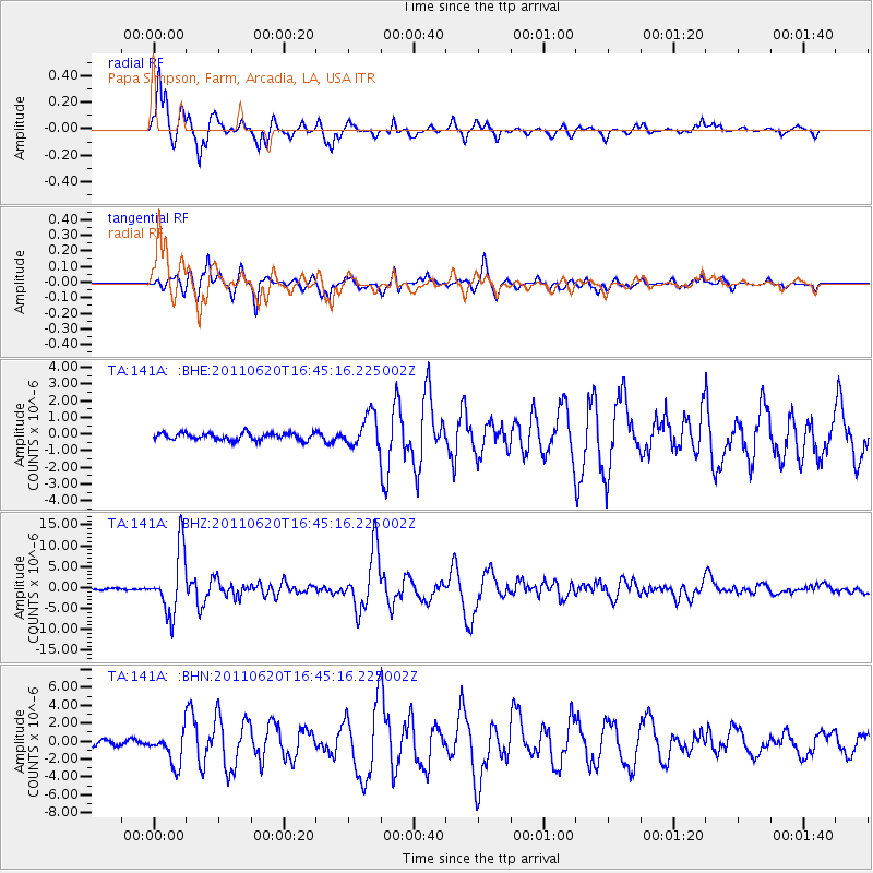
> Station 141A Papa Simpson, Farm, Arcadia, LA, USA > Earthquake Result Viewer
141A Papa Simpson, Farm, Arcadia, LA, USA - Earthquake Result Viewer
| Earthquake location: |
Chile-Bolivia Border Region |
| Earthquake latitude/longitude: |
-21.7/-68.2 |
| Earthquake time(UTC): |
2011/06/20 (171) 16:36:01 GMT |
| Earthquake Depth: |
128 km |
| Earthquake Magnitude: |
6.0 MB, 6.5 MW, 6.5 MW |
| Earthquake Catalog/Contributor: |
WHDF/NEIC |
|
| Network: |
TA USArray Transportable Network (new EarthScope stations) |
| Station: |
141A Papa Simpson, Farm, Arcadia, LA, USA |
| Lat/Lon: |
32.60 N/92.90 W |
| Elevation: |
91 m |
|
| Distance: |
58.9 deg |
| Az: |
335.706 deg |
| Baz: |
153.044 deg |
| Ray Param: |
0.06213361 |
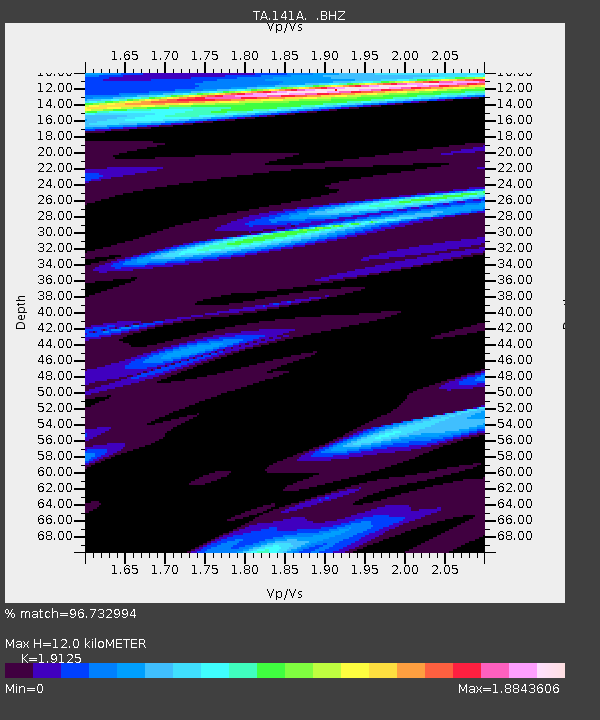
| Estimated Moho Depth: |
12.0 km |
| Estimated Crust Vp/Vs: |
1.91 |
| Assumed Crust Vp: |
6.245 km/s |
| Estimated Crust Vs: |
3.265 km/s |
| Estimated Crust Poisson's Ratio: |
0.31 |
|
| Radial Match: |
96.732994 % |
| Radial Bump: |
363 |
| Transverse Match: |
94.10542 % |
| Transverse Bump: |
374 |
| SOD ConfigId: |
395004 |
| Insert Time: |
2011-12-01 06:46:59.978 +0000 |
| GWidth: |
2.5 |
| Max Bumps: |
400 |
| Tol: |
0.001 |
|
Signal To Noise
| Channel | StoN | STA | LTA |
| TA:141A: :BHZ:20110620T16:45:16.225002Z | 43.485184 | 7.5348717E-6 | 1.7327446E-7 |
| TA:141A: :BHN:20110620T16:45:16.225002Z | 6.8563294 | 1.8294652E-6 | 2.6682866E-7 |
| TA:141A: :BHE:20110620T16:45:16.225002Z | 4.5784974 | 9.601342E-7 | 2.097051E-7 |
| Arrivals |
| Ps | 1.8 SECOND |
| PpPs | 5.4 SECOND |
| PsPs/PpSs | 7.2 SECOND |


