You are here: Home > Network List > G - GEOSCOPE Stations List
> Station AIS New Amsterdam, Indian Ocean > Earthquake Result Viewer
AIS New Amsterdam, Indian Ocean - Earthquake Result Viewer
| Earthquake location: |
Mindanao, Philippines |
| Earthquake latitude/longitude: |
6.9/126.6 |
| Earthquake time(UTC): |
2001/01/01 (001) 06:57:04 GMT |
| Earthquake Depth: |
33 km |
| Earthquake Magnitude: |
6.4 MB, 7.2 MS, 7.5 MW, 7.3 ME |
| Earthquake Catalog/Contributor: |
WHDF/NEIC |
|
| Network: |
G GEOSCOPE |
| Station: |
AIS New Amsterdam, Indian Ocean |
| Lat/Lon: |
37.80 S/77.57 E |
| Elevation: |
35 m |
|
| Distance: |
63.7 deg |
| Az: |
221.836 deg |
| Baz: |
56.717 deg |
| Ray Param: |
0.05935314 |
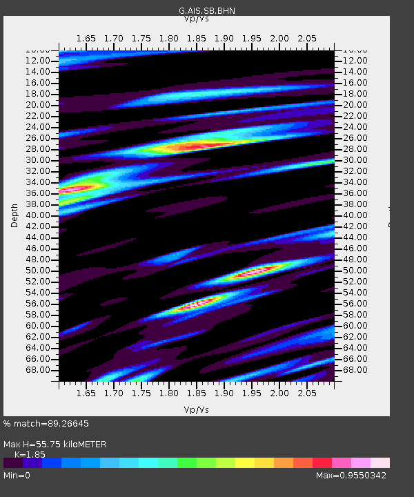
| Estimated Moho Depth: |
55.75 km |
| Estimated Crust Vp/Vs: |
1.85 |
| Assumed Crust Vp: |
4.802 km/s |
| Estimated Crust Vs: |
2.596 km/s |
| Estimated Crust Poisson's Ratio: |
0.29 |
|
| Radial Match: |
89.26645 % |
| Radial Bump: |
385 |
| Transverse Match: |
63.77744 % |
| Transverse Bump: |
400 |
| SOD ConfigId: |
3744 |
| Insert Time: |
2010-02-26 21:25:25.144 +0000 |
| GWidth: |
2.5 |
| Max Bumps: |
400 |
| Tol: |
0.001 |
|

Signal To Noise
| Channel | StoN | STA | LTA |
| G:AIS:SB:BHN:20010101T07:07:01.57802Z | 0.5245491 | 1.1163294E-6 | 2.1281694E-6 |
| G:AIS:SB:BHE:20010101T07:07:01.57802Z | 1.1110809 | 1.936413E-6 | 1.7428191E-6 |
| G:AIS:SB:BHZ:20010101T07:07:01.57802Z | 0.93115795 | 9.552256E-7 | 1.0258469E-6 |
| Arrivals |
| Ps | 10 SECOND |
| PpPs | 32 SECOND |
| PsPs/PpSs | 42 SECOND |


