You are here: Home > Network List > TA - USArray Transportable Network (new EarthScope stations) Stations List
> Station 144A alexander Place, Bentonia, MS, USA > Earthquake Result Viewer
144A alexander Place, Bentonia, MS, USA - Earthquake Result Viewer
| Earthquake location: |
Chile-Bolivia Border Region |
| Earthquake latitude/longitude: |
-21.7/-68.2 |
| Earthquake time(UTC): |
2011/06/20 (171) 16:36:01 GMT |
| Earthquake Depth: |
128 km |
| Earthquake Magnitude: |
6.0 MB, 6.5 MW, 6.5 MW |
| Earthquake Catalog/Contributor: |
WHDF/NEIC |
|
| Network: |
TA USArray Transportable Network (new EarthScope stations) |
| Station: |
144A alexander Place, Bentonia, MS, USA |
| Lat/Lon: |
32.63 N/90.42 W |
| Elevation: |
78 m |
|
| Distance: |
58.0 deg |
| Az: |
337.933 deg |
| Baz: |
155.54 deg |
| Ray Param: |
0.06271113 |
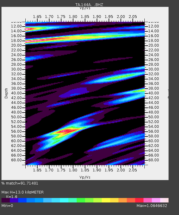
| Estimated Moho Depth: |
13.0 km |
| Estimated Crust Vp/Vs: |
1.60 |
| Assumed Crust Vp: |
6.201 km/s |
| Estimated Crust Vs: |
3.876 km/s |
| Estimated Crust Poisson's Ratio: |
0.18 |
|
| Radial Match: |
91.71481 % |
| Radial Bump: |
367 |
| Transverse Match: |
59.858242 % |
| Transverse Bump: |
400 |
| SOD ConfigId: |
395004 |
| Insert Time: |
2011-12-01 06:49:58.883 +0000 |
| GWidth: |
2.5 |
| Max Bumps: |
400 |
| Tol: |
0.001 |
|
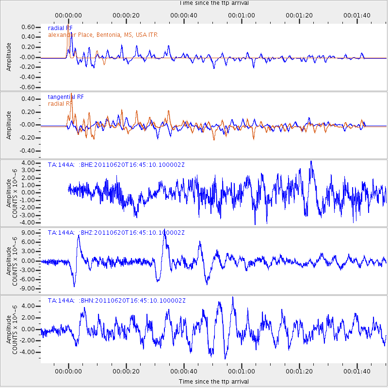
Signal To Noise
| Channel | StoN | STA | LTA |
| TA:144A: :BHZ:20110620T16:45:10.100002Z | 6.4205346 | 4.4556764E-6 | 6.939728E-7 |
| TA:144A: :BHN:20110620T16:45:10.100002Z | 2.3120487 | 1.5185826E-6 | 6.568126E-7 |
| TA:144A: :BHE:20110620T16:45:10.100002Z | 0.7472474 | 7.6786307E-7 | 1.0275888E-6 |
| Arrivals |
| Ps | 1.3 SECOND |
| PpPs | 5.2 SECOND |
| PsPs/PpSs | 6.5 SECOND |


