You are here: Home > Network List > TA - USArray Transportable Network (new EarthScope stations) Stations List
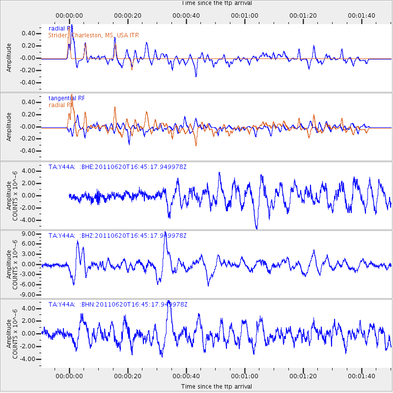
> Station Y44A Strider, Charleston, MS, USA > Earthquake Result Viewer
Y44A Strider, Charleston, MS, USA - Earthquake Result Viewer
| Earthquake location: |
Chile-Bolivia Border Region |
| Earthquake latitude/longitude: |
-21.7/-68.2 |
| Earthquake time(UTC): |
2011/06/20 (171) 16:36:01 GMT |
| Earthquake Depth: |
128 km |
| Earthquake Magnitude: |
6.0 MB, 6.5 MW, 6.5 MW |
| Earthquake Catalog/Contributor: |
WHDF/NEIC |
|
| Network: |
TA USArray Transportable Network (new EarthScope stations) |
| Station: |
Y44A Strider, Charleston, MS, USA |
| Lat/Lon: |
33.96 N/90.21 W |
| Elevation: |
46 m |
|
| Distance: |
59.2 deg |
| Az: |
338.76 deg |
| Baz: |
156.086 deg |
| Ray Param: |
0.06196899 |
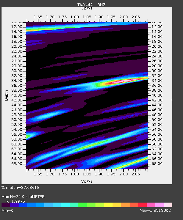
| Estimated Moho Depth: |
34.0 km |
| Estimated Crust Vp/Vs: |
2.00 |
| Assumed Crust Vp: |
6.201 km/s |
| Estimated Crust Vs: |
3.105 km/s |
| Estimated Crust Poisson's Ratio: |
0.33 |
|
| Radial Match: |
87.68618 % |
| Radial Bump: |
400 |
| Transverse Match: |
82.91526 % |
| Transverse Bump: |
400 |
| SOD ConfigId: |
395004 |
| Insert Time: |
2011-12-01 06:51:50.771 +0000 |
| GWidth: |
2.5 |
| Max Bumps: |
400 |
| Tol: |
0.001 |
|
Signal To Noise
| Channel | StoN | STA | LTA |
| TA:Y44A: :BHZ:20110620T16:45:17.949978Z | 12.5929785 | 3.7411144E-6 | 2.970794E-7 |
| TA:Y44A: :BHN:20110620T16:45:17.949978Z | 3.6073818 | 1.5325487E-6 | 4.2483683E-7 |
| TA:Y44A: :BHE:20110620T16:45:17.949978Z | 2.980413 | 1.362465E-6 | 4.571397E-7 |
| Arrivals |
| Ps | 5.7 SECOND |
| PpPs | 16 SECOND |
| PsPs/PpSs | 21 SECOND |


