You are here: Home > Network List > TA - USArray Transportable Network (new EarthScope stations) Stations List
> Station Z42A Norrel Spur, Hamburg, AR, USA > Earthquake Result Viewer
Z42A Norrel Spur, Hamburg, AR, USA - Earthquake Result Viewer
| Earthquake location: |
Chile-Bolivia Border Region |
| Earthquake latitude/longitude: |
-21.7/-68.2 |
| Earthquake time(UTC): |
2011/06/20 (171) 16:36:01 GMT |
| Earthquake Depth: |
128 km |
| Earthquake Magnitude: |
6.0 MB, 6.5 MW, 6.5 MW |
| Earthquake Catalog/Contributor: |
WHDF/NEIC |
|
| Network: |
TA USArray Transportable Network (new EarthScope stations) |
| Station: |
Z42A Norrel Spur, Hamburg, AR, USA |
| Lat/Lon: |
33.27 N/91.95 W |
| Elevation: |
39 m |
|
| Distance: |
59.2 deg |
| Az: |
336.893 deg |
| Baz: |
154.173 deg |
| Ray Param: |
0.06197747 |
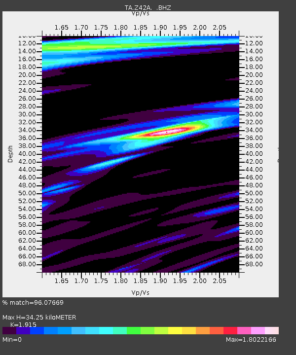
| Estimated Moho Depth: |
34.25 km |
| Estimated Crust Vp/Vs: |
1.91 |
| Assumed Crust Vp: |
6.201 km/s |
| Estimated Crust Vs: |
3.238 km/s |
| Estimated Crust Poisson's Ratio: |
0.31 |
|
| Radial Match: |
96.07669 % |
| Radial Bump: |
381 |
| Transverse Match: |
84.25402 % |
| Transverse Bump: |
400 |
| SOD ConfigId: |
395004 |
| Insert Time: |
2011-12-01 06:52:17.597 +0000 |
| GWidth: |
2.5 |
| Max Bumps: |
400 |
| Tol: |
0.001 |
|
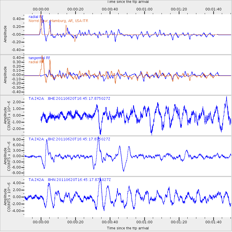
Signal To Noise
| Channel | StoN | STA | LTA |
| TA:Z42A: :BHZ:20110620T16:45:17.875027Z | 21.689823 | 4.323144E-6 | 1.9931669E-7 |
| TA:Z42A: :BHN:20110620T16:45:17.875027Z | 5.0376916 | 1.8885806E-6 | 3.748901E-7 |
| TA:Z42A: :BHE:20110620T16:45:17.875027Z | 3.12222 | 1.1783721E-6 | 3.774148E-7 |
| Arrivals |
| Ps | 5.3 SECOND |
| PpPs | 15 SECOND |
| PsPs/PpSs | 21 SECOND |


