You are here: Home > Network List > TA - USArray Transportable Network (new EarthScope stations) Stations List
> Station X44A Crenshaw, MS, USA > Earthquake Result Viewer
X44A Crenshaw, MS, USA - Earthquake Result Viewer
| Earthquake location: |
Chile-Bolivia Border Region |
| Earthquake latitude/longitude: |
-21.7/-68.2 |
| Earthquake time(UTC): |
2011/06/20 (171) 16:36:01 GMT |
| Earthquake Depth: |
128 km |
| Earthquake Magnitude: |
6.0 MB, 6.5 MW, 6.5 MW |
| Earthquake Catalog/Contributor: |
WHDF/NEIC |
|
| Network: |
TA USArray Transportable Network (new EarthScope stations) |
| Station: |
X44A Crenshaw, MS, USA |
| Lat/Lon: |
34.50 N/90.15 W |
| Elevation: |
109 m |
|
| Distance: |
59.7 deg |
| Az: |
339.069 deg |
| Baz: |
156.28 deg |
| Ray Param: |
0.06166519 |
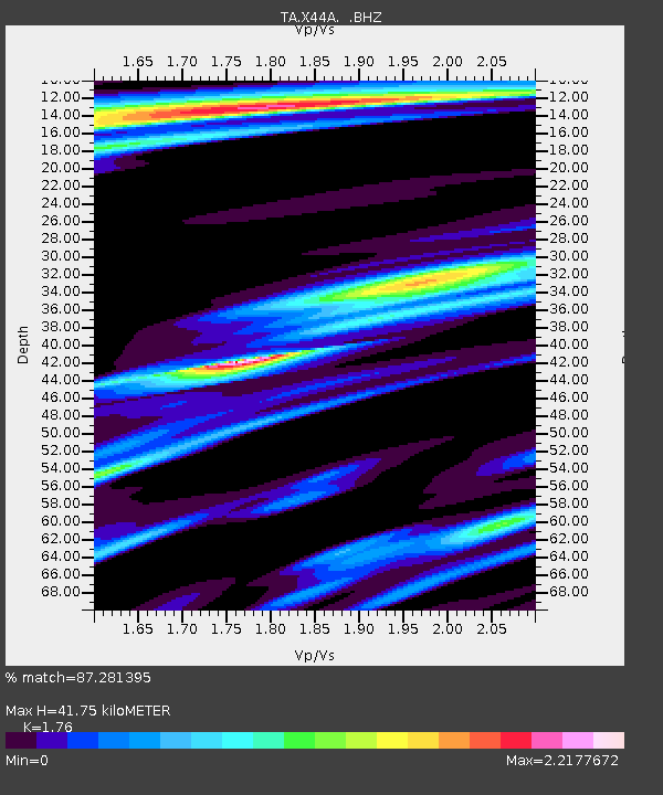
| Estimated Moho Depth: |
41.75 km |
| Estimated Crust Vp/Vs: |
1.76 |
| Assumed Crust Vp: |
6.273 km/s |
| Estimated Crust Vs: |
3.564 km/s |
| Estimated Crust Poisson's Ratio: |
0.26 |
|
| Radial Match: |
87.281395 % |
| Radial Bump: |
352 |
| Transverse Match: |
88.46858 % |
| Transverse Bump: |
386 |
| SOD ConfigId: |
395004 |
| Insert Time: |
2011-12-01 06:53:20.882 +0000 |
| GWidth: |
2.5 |
| Max Bumps: |
400 |
| Tol: |
0.001 |
|
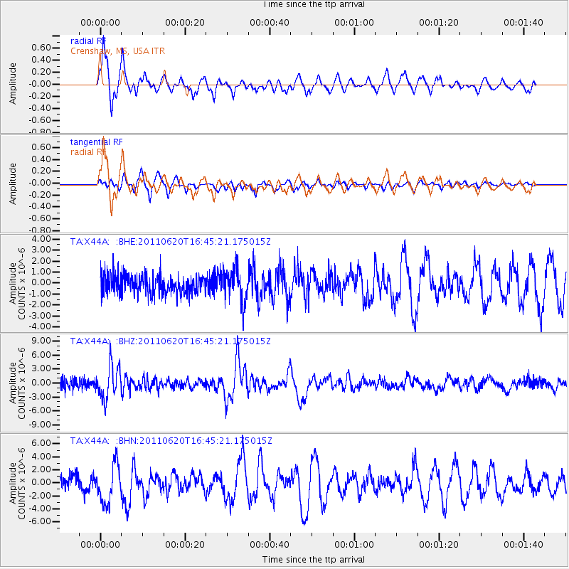
Signal To Noise
| Channel | StoN | STA | LTA |
| TA:X44A: :BHZ:20110620T16:45:21.175015Z | 4.2496424 | 3.6694983E-6 | 8.6348405E-7 |
| TA:X44A: :BHN:20110620T16:45:21.175015Z | 3.13468 | 3.0023973E-6 | 9.578002E-7 |
| TA:X44A: :BHE:20110620T16:45:21.175015Z | 1.7677078 | 1.5053838E-6 | 8.516022E-7 |
| Arrivals |
| Ps | 5.3 SECOND |
| PpPs | 18 SECOND |
| PsPs/PpSs | 23 SECOND |


