You are here: Home > Network List > TA - USArray Transportable Network (new EarthScope stations) Stations List
> Station V42A Cord, AR, USA > Earthquake Result Viewer
V42A Cord, AR, USA - Earthquake Result Viewer
| Earthquake location: |
Chile-Bolivia Border Region |
| Earthquake latitude/longitude: |
-21.7/-68.2 |
| Earthquake time(UTC): |
2011/06/20 (171) 16:36:01 GMT |
| Earthquake Depth: |
128 km |
| Earthquake Magnitude: |
6.0 MB, 6.5 MW, 6.5 MW |
| Earthquake Catalog/Contributor: |
WHDF/NEIC |
|
| Network: |
TA USArray Transportable Network (new EarthScope stations) |
| Station: |
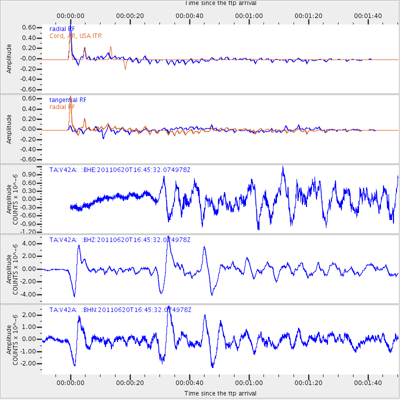
V42A Cord, AR, USA |
| Lat/Lon: |
35.81 N/91.39 W |
| Elevation: |
134 m |
|
| Distance: |
61.3 deg |
| Az: |
338.614 deg |
| Baz: |
155.342 deg |
| Ray Param: |
0.060624264 |
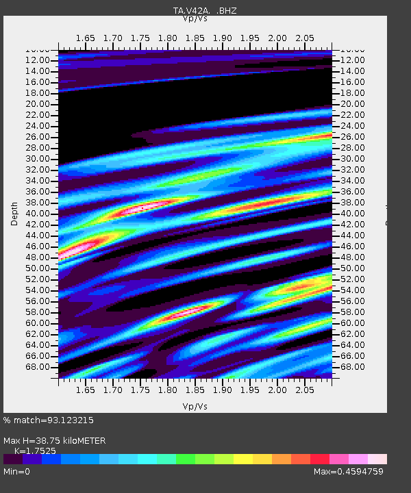
| Estimated Moho Depth: |
38.75 km |
| Estimated Crust Vp/Vs: |
1.75 |
| Assumed Crust Vp: |
6.273 km/s |
| Estimated Crust Vs: |
3.58 km/s |
| Estimated Crust Poisson's Ratio: |
0.26 |
|
| Radial Match: |
93.123215 % |
| Radial Bump: |
400 |
| Transverse Match: |
79.98647 % |
| Transverse Bump: |
400 |
| SOD ConfigId: |
395004 |
| Insert Time: |
2011-12-01 06:54:12.202 +0000 |
| GWidth: |
2.5 |
| Max Bumps: |
400 |
| Tol: |
0.001 |
|
Signal To Noise
| Channel | StoN | STA | LTA |
| TA:V42A: :BHZ:20110620T16:45:32.074978Z | 34.214333 | 2.3483801E-6 | 6.863732E-8 |
| TA:V42A: :BHN:20110620T16:45:32.074978Z | 7.3521614 | 1.2235454E-6 | 1.6641982E-7 |
| TA:V42A: :BHE:20110620T16:45:32.074978Z | 2.5126686 | 4.5019652E-7 | 1.7917068E-7 |
| Arrivals |
| Ps | 4.9 SECOND |
| PpPs | 16 SECOND |
| PsPs/PpSs | 21 SECOND |


