You are here: Home > Network List > XL12 - Hangay Dome, Mongolia Stations List
> Station HD27 HD27 > Earthquake Result Viewer
HD27 HD27 - Earthquake Result Viewer
| Earthquake location: |
Nicobar Islands, India Region |
| Earthquake latitude/longitude: |
7.5/94.3 |
| Earthquake time(UTC): |
2014/03/21 (080) 14:11:13 GMT |
| Earthquake Depth: |
10 km |
| Earthquake Magnitude: |
5.5 MB |
| Earthquake Catalog/Contributor: |
NEIC PDE/NEIC COMCAT |
|
| Network: |
XL Hangay Dome, Mongolia |
| Station: |
HD27 HD27 |
| Lat/Lon: |
47.32 N/98.40 E |
| Elevation: |
2547 m |
|
| Distance: |
39.8 deg |
| Az: |
4.392 deg |
| Baz: |
186.407 deg |
| Ray Param: |
0.07477782 |
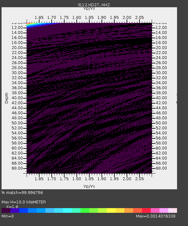
| Estimated Moho Depth: |
10.0 km |
| Estimated Crust Vp/Vs: |
1.60 |
| Assumed Crust Vp: |
6.642 km/s |
| Estimated Crust Vs: |
4.151 km/s |
| Estimated Crust Poisson's Ratio: |
0.18 |
|
| Radial Match: |
99.996796 % |
| Radial Bump: |
2 |
| Transverse Match: |
99.645355 % |
| Transverse Bump: |
14 |
| SOD ConfigId: |
3390531 |
| Insert Time: |
2019-04-10 19:24:27.494 +0000 |
| GWidth: |
2.5 |
| Max Bumps: |
400 |
| Tol: |
0.001 |
|

Signal To Noise
| Channel | StoN | STA | LTA |
| XL:HD27: :HHZ:20140321T14:18:16.369004Z | 2.1549616 | 2.7293222E-6 | 1.2665295E-6 |
| XL:HD27: :HHN:20140321T14:18:16.369004Z | 2.1489377 | 3.3093265E-6 | 1.5399825E-6 |
| XL:HD27: :HHE:20140321T14:18:16.369004Z | 1.8841215 | 3.323879E-8 | 1.7641533E-8 |
| Arrivals |
| Ps | 1.0 SECOND |
| PpPs | 3.6 SECOND |
| PsPs/PpSs | 4.6 SECOND |


