You are here: Home > Network List > TA - USArray Transportable Network (new EarthScope stations) Stations List
> Station P41A Barry, Barry, IL, USA > Earthquake Result Viewer
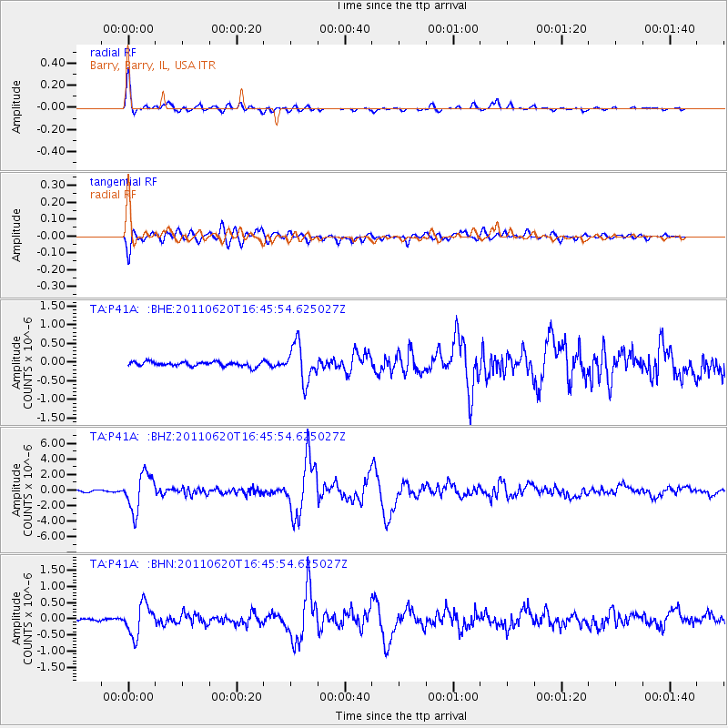
P41A Barry, Barry, IL, USA - Earthquake Result Viewer

| Earthquake location: |
Chile-Bolivia Border Region |
| Earthquake latitude/longitude: |
-21.7/-68.2 |
| Earthquake time(UTC): |
2011/06/20 (171) 16:36:01 GMT |
| Earthquake Depth: |
128 km |
| Earthquake Magnitude: |
6.0 MB, 6.5 MW, 6.5 MW |
| Earthquake Catalog/Contributor: |
WHDF/NEIC |
|
| Network: |
TA USArray Transportable Network (new EarthScope stations) |
| Station: |
P41A Barry, Barry, IL, USA |
| Lat/Lon: |
39.67 N/91.06 W |
| Elevation: |
215 m |
|
| Distance: |
64.7 deg |
| Az: |
340.65 deg |
| Baz: |
156.469 deg |
| Ray Param: |
0.058412362 |
| Estimated Moho Depth: |
42.25 km |
| Estimated Crust Vp/Vs: |
1.97 |
| Assumed Crust Vp: |
6.498 km/s |
| Estimated Crust Vs: |
3.307 km/s |
| Estimated Crust Poisson's Ratio: |
0.33 |
|
| Radial Match: |
95.26845 % |
| Radial Bump: |
393 |
| Transverse Match: |
87.724045 % |
| Transverse Bump: |
400 |
| SOD ConfigId: |
395004 |
| Insert Time: |
2011-12-01 06:55:14.912 +0000 |
| GWidth: |
2.5 |
| Max Bumps: |
400 |
| Tol: |
0.001 |
|
Signal To Noise
| Channel | StoN | STA | LTA |
| TA:P41A: :BHZ:20110620T16:45:54.625027Z | 23.367077 | 2.3579253E-6 | 1.00908004E-7 |
| TA:P41A: :BHN:20110620T16:45:54.625027Z | 5.8669553 | 4.87924E-7 | 8.316477E-8 |
| TA:P41A: :BHE:20110620T16:45:54.625027Z | 8.403815 | 5.00087E-7 | 5.9507137E-8 |
| Arrivals |
| Ps | 6.5 SECOND |
| PpPs | 19 SECOND |
| PsPs/PpSs | 25 SECOND |


