You are here: Home > Network List > TA - USArray Transportable Network (new EarthScope stations) Stations List
> Station J39A Decorah, IA, USA > Earthquake Result Viewer
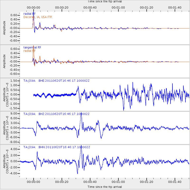
J39A Decorah, IA, USA - Earthquake Result Viewer

| Earthquake location: |
Chile-Bolivia Border Region |
| Earthquake latitude/longitude: |
-21.7/-68.2 |
| Earthquake time(UTC): |
2011/06/20 (171) 16:36:01 GMT |
| Earthquake Depth: |
128 km |
| Earthquake Magnitude: |
6.0 MB, 6.5 MW, 6.5 MW |
| Earthquake Catalog/Contributor: |
WHDF/NEIC |
|
| Network: |
TA USArray Transportable Network (new EarthScope stations) |
| Station: |
J39A Decorah, IA, USA |
| Lat/Lon: |
43.34 N/91.71 W |
| Elevation: |
350 m |
|
| Distance: |
68.2 deg |
| Az: |
341.758 deg |
| Baz: |
156.486 deg |
| Ray Param: |
0.05610383 |
| Estimated Moho Depth: |
35.0 km |
| Estimated Crust Vp/Vs: |
1.84 |
| Assumed Crust Vp: |
6.53 km/s |
| Estimated Crust Vs: |
3.559 km/s |
| Estimated Crust Poisson's Ratio: |
0.29 |
|
| Radial Match: |
97.280075 % |
| Radial Bump: |
400 |
| Transverse Match: |
90.29759 % |
| Transverse Bump: |
400 |
| SOD ConfigId: |
395004 |
| Insert Time: |
2011-12-01 06:55:55.287 +0000 |
| GWidth: |
2.5 |
| Max Bumps: |
400 |
| Tol: |
0.001 |
|
Signal To Noise
| Channel | StoN | STA | LTA |
| TA:J39A: :BHZ:20110620T16:46:17.100002Z | 28.60024 | 2.560307E-6 | 8.952047E-8 |
| TA:J39A: :BHN:20110620T16:46:17.100002Z | 9.021956 | 1.3317509E-6 | 1.4761221E-7 |
| TA:J39A: :BHE:20110620T16:46:17.100002Z | 4.647699 | 4.4446017E-7 | 9.5630156E-8 |
| Arrivals |
| Ps | 4.6 SECOND |
| PpPs | 15 SECOND |
| PsPs/PpSs | 19 SECOND |


