You are here: Home > Network List > UO - University of Oregon Regional Network Stations List
> Station DBO Dodson Butte, OR (UO CREST BB SMO) > Earthquake Result Viewer
DBO Dodson Butte, OR (UO CREST BB SMO) - Earthquake Result Viewer
| Earthquake location: |
Chile-Bolivia Border Region |
| Earthquake latitude/longitude: |
-21.7/-68.2 |
| Earthquake time(UTC): |
2011/06/20 (171) 16:36:01 GMT |
| Earthquake Depth: |
128 km |
| Earthquake Magnitude: |
6.0 MB, 6.5 MW, 6.5 MW |
| Earthquake Catalog/Contributor: |
WHDF/NEIC |
|
| Network: |
UO University of Oregon Regional Network |
| Station: |
DBO Dodson Butte, OR (UO CREST BB SMO) |
| Lat/Lon: |
43.12 N/123.24 W |
| Elevation: |
984 m |
|
| Distance: |
81.9 deg |
| Az: |
322.707 deg |
| Baz: |
129.689 deg |
| Ray Param: |
0.046934698 |
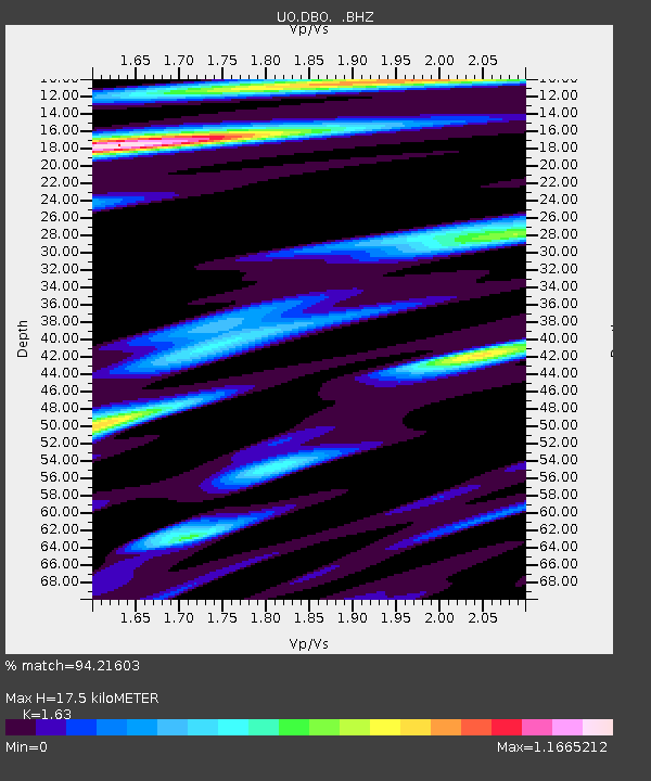
| Estimated Moho Depth: |
17.5 km |
| Estimated Crust Vp/Vs: |
1.63 |
| Assumed Crust Vp: |
6.522 km/s |
| Estimated Crust Vs: |
4.001 km/s |
| Estimated Crust Poisson's Ratio: |
0.20 |
|
| Radial Match: |
94.21603 % |
| Radial Bump: |
400 |
| Transverse Match: |
91.36665 % |
| Transverse Bump: |
400 |
| SOD ConfigId: |
395004 |
| Insert Time: |
2011-12-01 06:56:13.246 +0000 |
| GWidth: |
2.5 |
| Max Bumps: |
400 |
| Tol: |
0.001 |
|

Signal To Noise
| Channel | StoN | STA | LTA |
| UO:DBO: :BHZ:20110620T16:47:35.566982Z | 17.34178 | 2.8046816E-6 | 1.6172973E-7 |
| UO:DBO: :BHN:20110620T16:47:35.566982Z | 5.323874 | 7.9238663E-7 | 1.4883648E-7 |
| UO:DBO: :BHE:20110620T16:47:35.566982Z | 6.898538 | 8.138248E-7 | 1.17970615E-7 |
| Arrivals |
| Ps | 1.7 SECOND |
| PpPs | 6.9 SECOND |
| PsPs/PpSs | 8.6 SECOND |


