You are here: Home > Network List > UW - Pacific Northwest Regional Seismic Network Stations List
> Station UMAT Pilot Rock, OR, USA > Earthquake Result Viewer
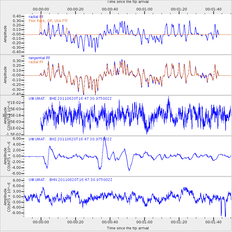
UMAT Pilot Rock, OR, USA - Earthquake Result Viewer
*The percent match for this event was below the threshold and hence no stack was calculated.
| Earthquake location: |
Chile-Bolivia Border Region |
| Earthquake latitude/longitude: |
-21.7/-68.2 |
| Earthquake time(UTC): |
2011/06/20 (171) 16:36:01 GMT |
| Earthquake Depth: |
128 km |
| Earthquake Magnitude: |
6.0 MB, 6.5 MW, 6.5 MW |
| Earthquake Catalog/Contributor: |
WHDF/NEIC |
|
| Network: |
UW Pacific Northwest Regional Seismic Network |
| Station: |
UMAT Pilot Rock, OR, USA |
| Lat/Lon: |
45.29 N/118.96 W |
| Elevation: |
1318 m |
|
| Distance: |
81.1 deg |
| Az: |
326.414 deg |
| Baz: |
133.214 deg |
| Ray Param: |
$rayparam |
*The percent match for this event was below the threshold and hence was not used in the summary stack. |
|
| Radial Match: |
42.28299 % |
| Radial Bump: |
400 |
| Transverse Match: |
42.339046 % |
| Transverse Bump: |
400 |
| SOD ConfigId: |
395004 |
| Insert Time: |
2011-12-01 06:59:13.167 +0000 |
| GWidth: |
2.5 |
| Max Bumps: |
400 |
| Tol: |
0.001 |
|
Signal To Noise
| Channel | StoN | STA | LTA |
| UW:UMAT: :BHZ:20110620T16:47:30.975002Z | 39.423122 | 1.8817935E-6 | 4.7733245E-8 |
| UW:UMAT: :BHN:20110620T16:47:30.975002Z | 1.4364517 | 2.200045E-6 | 1.5315829E-6 |
| UW:UMAT: :BHE:20110620T16:47:30.975002Z | 0.8430947 | 3.892587E-9 | 4.6170223E-9 |
| Arrivals |
| Ps | |
| PpPs | |
| PsPs/PpSs | |


