You are here: Home > Network List > AZ - ANZA Regional Network Stations List
> Station SMER AZ.SMER > Earthquake Result Viewer
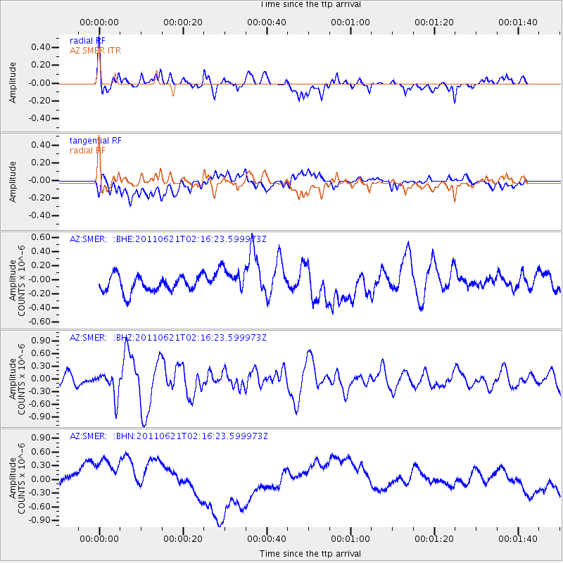
SMER AZ.SMER - Earthquake Result Viewer
*The percent match for this event was below the threshold and hence no stack was calculated.
| Earthquake location: |
Santa Cruz Islands |
| Earthquake latitude/longitude: |
-11.5/165.6 |
| Earthquake time(UTC): |
2011/06/21 (172) 02:04:15 GMT |
| Earthquake Depth: |
14 km |
| Earthquake Magnitude: |
5.8 MB, 5.8 MS, 6.0 MW, 6.0 MW |
| Earthquake Catalog/Contributor: |
WHDF/NEIC |
|
| Network: |
AZ ANZA Regional Network |
| Station: |
SMER AZ.SMER |
| Lat/Lon: |
33.46 N/117.17 W |
| Elevation: |
355 m |
|
| Distance: |
85.9 deg |
| Az: |
54.844 deg |
| Baz: |
253.471 deg |
| Ray Param: |
$rayparam |
*The percent match for this event was below the threshold and hence was not used in the summary stack. |
|
| Radial Match: |
40.147465 % |
| Radial Bump: |
400 |
| Transverse Match: |
13.660906 % |
| Transverse Bump: |
400 |
| SOD ConfigId: |
395004 |
| Insert Time: |
2011-12-01 07:07:41.555 +0000 |
| GWidth: |
2.5 |
| Max Bumps: |
400 |
| Tol: |
0.001 |
|
Signal To Noise
| Channel | StoN | STA | LTA |
| AZ:SMER: :BHZ:20110621T02:16:23.599973Z | 2.6119528 | 3.0618804E-7 | 1.1722572E-7 |
| AZ:SMER: :BHN:20110621T02:16:23.599973Z | 3.2462478 | 4.8762803E-7 | 1.5021283E-7 |
| AZ:SMER: :BHE:20110621T02:16:23.599973Z | 1.542582 | 1.7569504E-7 | 1.1389672E-7 |
| Arrivals |
| Ps | |
| PpPs | |
| PsPs/PpSs | |


