You are here: Home > Network List > G - GEOSCOPE Stations List
> Station ATD Arta Cave, Djibouti > Earthquake Result Viewer
ATD Arta Cave, Djibouti - Earthquake Result Viewer
| Earthquake location: |
Afghanistan-Tajikistan Bord Reg. |
| Earthquake latitude/longitude: |
36.4/71.5 |
| Earthquake time(UTC): |
2001/11/23 (327) 20:43:03 GMT |
| Earthquake Depth: |
106 km |
| Earthquake Magnitude: |
5.9 MB, 6.1 MW, 6.0 MW |
| Earthquake Catalog/Contributor: |
WHDF/NEIC |
|
| Network: |
G GEOSCOPE |
| Station: |
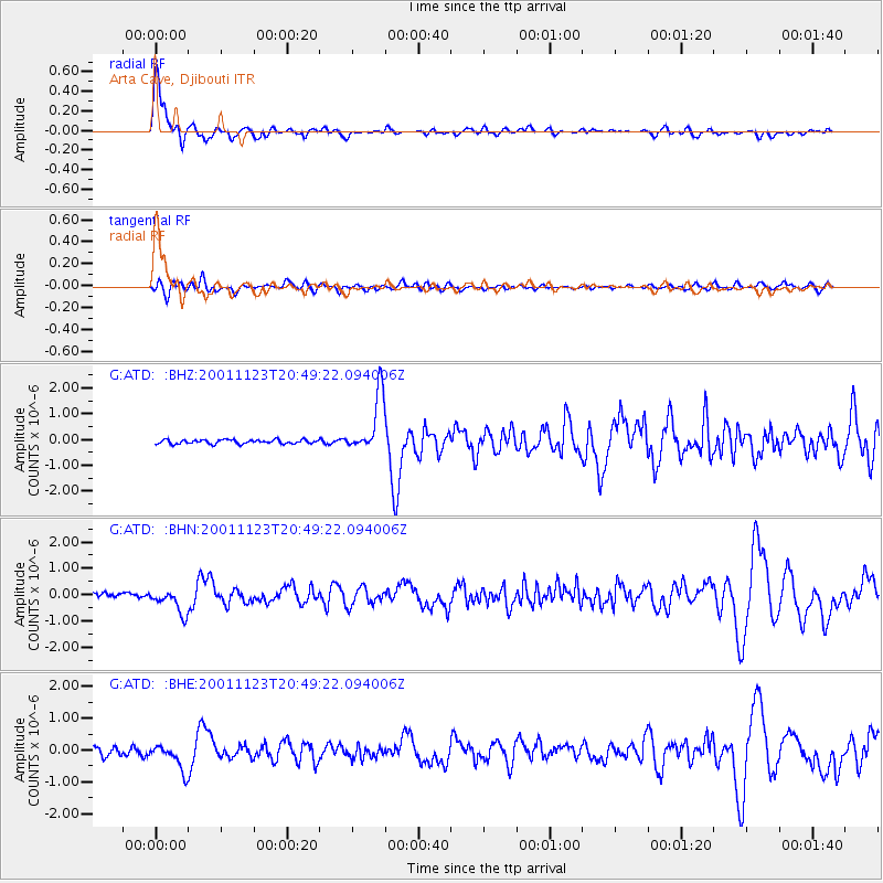
ATD Arta Cave, Djibouti |
| Lat/Lon: |
11.53 N/42.85 E |
| Elevation: |
610 m |
|
| Distance: |
35.8 deg |
| Az: |
233.502 deg |
| Baz: |
41.438 deg |
| Ray Param: |
0.07668747 |
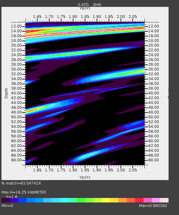
| Estimated Moho Depth: |
16.25 km |
| Estimated Crust Vp/Vs: |
1.60 |
| Assumed Crust Vp: |
6.375 km/s |
| Estimated Crust Vs: |
3.984 km/s |
| Estimated Crust Poisson's Ratio: |
0.18 |
|
| Radial Match: |
93.547424 % |
| Radial Bump: |
394 |
| Transverse Match: |
60.672806 % |
| Transverse Bump: |
400 |
| SOD ConfigId: |
20082 |
| Insert Time: |
2010-02-26 21:25:57.555 +0000 |
| GWidth: |
2.5 |
| Max Bumps: |
400 |
| Tol: |
0.001 |
|
Signal To Noise
| Channel | StoN | STA | LTA |
| G:ATD: :BHN:20011123T20:49:22.094006Z | 4.420064 | 4.97457E-7 | 1.125452E-7 |
| G:ATD: :BHE:20011123T20:49:22.094006Z | 2.951166 | 4.1951432E-7 | 1.4215206E-7 |
| G:ATD: :BHZ:20011123T20:49:22.094006Z | 14.433069 | 1.1358884E-6 | 7.87004E-8 |
| Arrivals |
| Ps | 1.7 SECOND |
| PpPs | 6.1 SECOND |
| PsPs/PpSs | 7.8 SECOND |


