You are here: Home > Network List > TA - USArray Transportable Network (new EarthScope stations) Stations List
> Station H17A Grant Village (NPS), Yellowstone Nt. Park, WY, USA > Earthquake Result Viewer
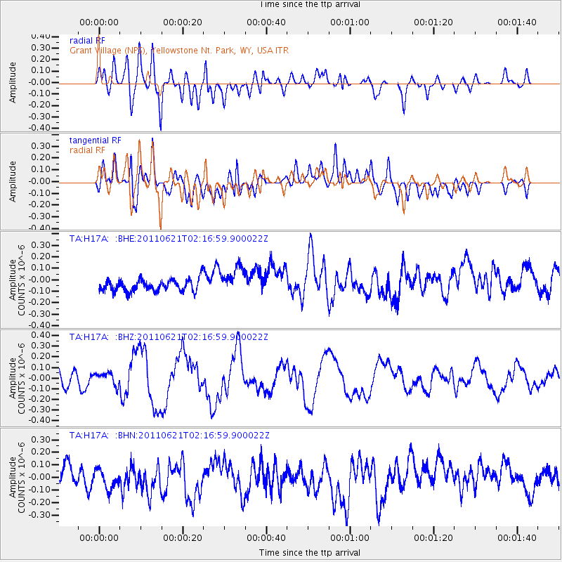
H17A Grant Village (NPS), Yellowstone Nt. Park, WY, USA - Earthquake Result Viewer
*The percent match for this event was below the threshold and hence no stack was calculated.
| Earthquake location: |
Santa Cruz Islands |
| Earthquake latitude/longitude: |
-11.5/165.6 |
| Earthquake time(UTC): |
2011/06/21 (172) 02:04:15 GMT |
| Earthquake Depth: |
14 km |
| Earthquake Magnitude: |
5.8 MB, 5.8 MS, 6.0 MW, 6.0 MW |
| Earthquake Catalog/Contributor: |
WHDF/NEIC |
|
| Network: |
TA USArray Transportable Network (new EarthScope stations) |
| Station: |
H17A Grant Village (NPS), Yellowstone Nt. Park, WY, USA |
| Lat/Lon: |
44.40 N/110.58 W |
| Elevation: |
2400 m |
|
| Distance: |
93.6 deg |
| Az: |
45.577 deg |
| Baz: |
257.577 deg |
| Ray Param: |
$rayparam |
*The percent match for this event was below the threshold and hence was not used in the summary stack. |
|
| Radial Match: |
61.00599 % |
| Radial Bump: |
400 |
| Transverse Match: |
58.88107 % |
| Transverse Bump: |
400 |
| SOD ConfigId: |
395004 |
| Insert Time: |
2011-12-01 07:18:13.453 +0000 |
| GWidth: |
2.5 |
| Max Bumps: |
400 |
| Tol: |
0.001 |
|
Signal To Noise
| Channel | StoN | STA | LTA |
| TA:H17A: :BHZ:20110621T02:16:59.900022Z | 1.2132841 | 5.764648E-8 | 4.7512764E-8 |
| TA:H17A: :BHN:20110621T02:16:59.900022Z | 1.3444276 | 8.905239E-8 | 6.6238144E-8 |
| TA:H17A: :BHE:20110621T02:16:59.900022Z | 2.3376257 | 1.1993555E-7 | 5.130656E-8 |
| Arrivals |
| Ps | |
| PpPs | |
| PsPs/PpSs | |


