You are here: Home > Network List > TA - USArray Transportable Network (new EarthScope stations) Stations List
> Station MSTX Muleshoe, TX, USA > Earthquake Result Viewer
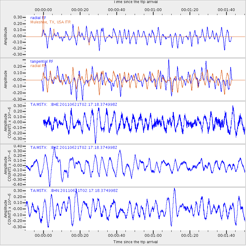
MSTX Muleshoe, TX, USA - Earthquake Result Viewer
*The percent match for this event was below the threshold and hence no stack was calculated.
| Earthquake location: |
Santa Cruz Islands |
| Earthquake latitude/longitude: |
-11.5/165.6 |
| Earthquake time(UTC): |
2011/06/21 (172) 02:04:15 GMT |
| Earthquake Depth: |
14 km |
| Earthquake Magnitude: |
5.8 MB, 5.8 MS, 6.0 MW, 6.0 MW |
| Earthquake Catalog/Contributor: |
WHDF/NEIC |
|
| Network: |
TA USArray Transportable Network (new EarthScope stations) |
| Station: |
MSTX Muleshoe, TX, USA |
| Lat/Lon: |
33.97 N/102.77 W |
| Elevation: |
1167 m |
|
| Distance: |
97.7 deg |
| Az: |
56.956 deg |
| Baz: |
261.389 deg |
| Ray Param: |
$rayparam |
*The percent match for this event was below the threshold and hence was not used in the summary stack. |
|
| Radial Match: |
39.128822 % |
| Radial Bump: |
400 |
| Transverse Match: |
50.47156 % |
| Transverse Bump: |
400 |
| SOD ConfigId: |
395004 |
| Insert Time: |
2011-12-01 07:18:27.362 +0000 |
| GWidth: |
2.5 |
| Max Bumps: |
400 |
| Tol: |
0.001 |
|
Signal To Noise
| Channel | StoN | STA | LTA |
| TA:MSTX: :BHZ:20110621T02:17:18.374998Z | 2.4474902 | 1.9895079E-7 | 8.128767E-8 |
| TA:MSTX: :BHN:20110621T02:17:18.374998Z | 1.9669985 | 1.6730897E-7 | 8.5058005E-8 |
| TA:MSTX: :BHE:20110621T02:17:18.374998Z | 1.8578763 | 1.5383742E-7 | 8.280283E-8 |
| Arrivals |
| Ps | |
| PpPs | |
| PsPs/PpSs | |


