You are here: Home > Network List > AU - Australian Seismological Centre Stations List
> Station TOO Toolangi, Victoria > Earthquake Result Viewer
TOO Toolangi, Victoria - Earthquake Result Viewer
| Earthquake location: |
Fox Islands, Aleutian Islands |
| Earthquake latitude/longitude: |
52.0/-171.8 |
| Earthquake time(UTC): |
2011/06/24 (175) 03:09:39 GMT |
| Earthquake Depth: |
52 km |
| Earthquake Magnitude: |
6.9 MB, 7.3 MW, 7.3 MW |
| Earthquake Catalog/Contributor: |
WHDF/NEIC |
|
| Network: |
AU Australian Seismological Centre |
| Station: |
TOO Toolangi, Victoria |
| Lat/Lon: |
37.57 S/145.49 E |
| Elevation: |
604 m |
|
| Distance: |
96.7 deg |
| Az: |
212.839 deg |
| Baz: |
24.927 deg |
| Ray Param: |
0.040400647 |
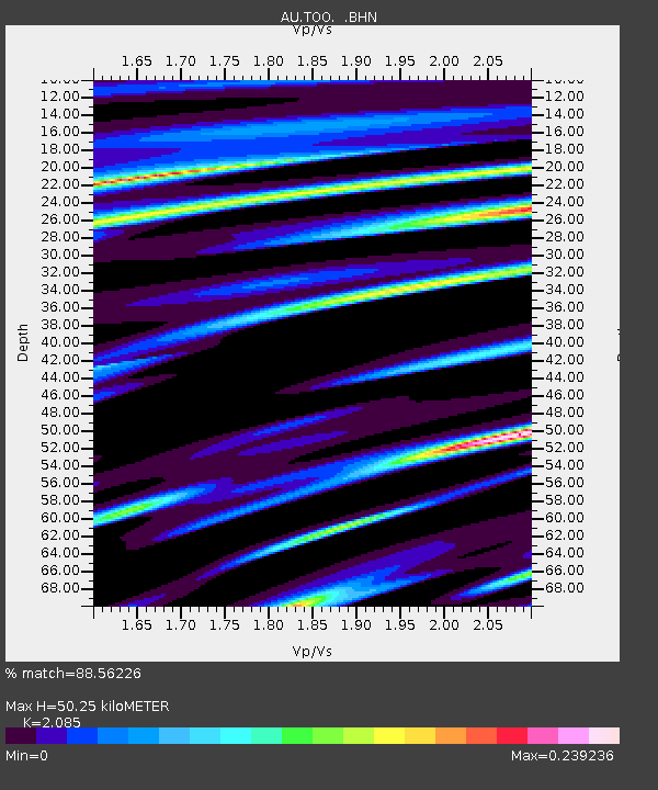
| Estimated Moho Depth: |
50.25 km |
| Estimated Crust Vp/Vs: |
2.09 |
| Assumed Crust Vp: |
6.577 km/s |
| Estimated Crust Vs: |
3.154 km/s |
| Estimated Crust Poisson's Ratio: |
0.35 |
|
| Radial Match: |
88.56226 % |
| Radial Bump: |
303 |
| Transverse Match: |
78.95504 % |
| Transverse Bump: |
400 |
| SOD ConfigId: |
395004 |
| Insert Time: |
2011-12-01 07:35:59.636 +0000 |
| GWidth: |
2.5 |
| Max Bumps: |
400 |
| Tol: |
0.001 |
|

Signal To Noise
| Channel | StoN | STA | LTA |
| AU:TOO: :BHZ:20110624T03:22:32.795012Z | 2.378237 | 1.0486851E-6 | 4.4095063E-7 |
| AU:TOO: :BHN:20110624T03:22:32.795012Z | 1.4724066 | 4.4594586E-7 | 3.0286867E-7 |
| AU:TOO: :BHE:20110624T03:22:32.795012Z | 2.550709 | 4.1722947E-7 | 1.6357392E-7 |
| Arrivals |
| Ps | 8.4 SECOND |
| PpPs | 23 SECOND |
| PsPs/PpSs | 32 SECOND |


