You are here: Home > Network List > AU - Australian Seismological Centre Stations List
> Station MTN Manton Dam, Northern Territory > Earthquake Result Viewer
MTN Manton Dam, Northern Territory - Earthquake Result Viewer
| Earthquake location: |
Fox Islands, Aleutian Islands |
| Earthquake latitude/longitude: |
52.0/-171.8 |
| Earthquake time(UTC): |
2011/06/24 (175) 03:09:39 GMT |
| Earthquake Depth: |
52 km |
| Earthquake Magnitude: |
6.9 MB, 7.3 MW, 7.3 MW |
| Earthquake Catalog/Contributor: |
WHDF/NEIC |
|
| Network: |
AU Australian Seismological Centre |
| Station: |
MTN Manton Dam, Northern Territory |
| Lat/Lon: |
12.84 S/131.13 E |
| Elevation: |
137 m |
|
| Distance: |
81.1 deg |
| Az: |
235.907 deg |
| Baz: |
31.625 deg |
| Ray Param: |
0.047701534 |
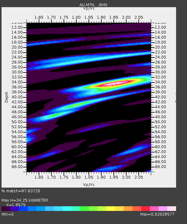
| Estimated Moho Depth: |
34.25 km |
| Estimated Crust Vp/Vs: |
1.96 |
| Assumed Crust Vp: |
6.61 km/s |
| Estimated Crust Vs: |
3.377 km/s |
| Estimated Crust Poisson's Ratio: |
0.32 |
|
| Radial Match: |
97.63728 % |
| Radial Bump: |
298 |
| Transverse Match: |
93.52493 % |
| Transverse Bump: |
400 |
| SOD ConfigId: |
395004 |
| Insert Time: |
2011-12-01 07:36:25.134 +0000 |
| GWidth: |
2.5 |
| Max Bumps: |
400 |
| Tol: |
0.001 |
|

Signal To Noise
| Channel | StoN | STA | LTA |
| AU:MTN: :BHZ:20110624T03:21:18.295012Z | 18.199635 | 3.8820644E-6 | 2.1330452E-7 |
| AU:MTN: :BHN:20110624T03:21:18.295012Z | 6.336834 | 1.5722234E-6 | 2.4810865E-7 |
| AU:MTN: :BHE:20110624T03:21:18.295012Z | 6.227318 | 9.608136E-7 | 1.5429013E-7 |
| Arrivals |
| Ps | 5.1 SECOND |
| PpPs | 15 SECOND |
| PsPs/PpSs | 20 SECOND |


