You are here: Home > Network List > AU - Australian Seismological Centre Stations List
> Station MANU Manus Island, Papau New Guinea > Earthquake Result Viewer
MANU Manus Island, Papau New Guinea - Earthquake Result Viewer
| Earthquake location: |
Fox Islands, Aleutian Islands |
| Earthquake latitude/longitude: |
52.0/-171.8 |
| Earthquake time(UTC): |
2011/06/24 (175) 03:09:39 GMT |
| Earthquake Depth: |
52 km |
| Earthquake Magnitude: |
6.9 MB, 7.3 MW, 7.3 MW |
| Earthquake Catalog/Contributor: |
WHDF/NEIC |
|
| Network: |
AU Australian Seismological Centre |
| Station: |
MANU Manus Island, Papau New Guinea |
| Lat/Lon: |
2.04 S/147.37 E |
| Elevation: |
142 m |
|
| Distance: |
63.9 deg |
| Az: |
226.627 deg |
| Baz: |
26.69 deg |
| Ray Param: |
0.059134208 |
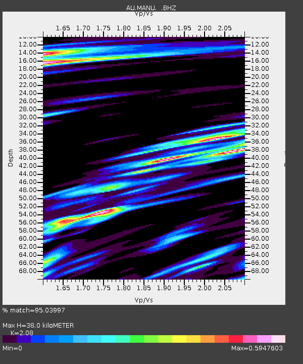
| Estimated Moho Depth: |
38.0 km |
| Estimated Crust Vp/Vs: |
2.08 |
| Assumed Crust Vp: |
4.082 km/s |
| Estimated Crust Vs: |
1.963 km/s |
| Estimated Crust Poisson's Ratio: |
0.35 |
|
| Radial Match: |
95.03997 % |
| Radial Bump: |
400 |
| Transverse Match: |
90.13984 % |
| Transverse Bump: |
400 |
| SOD ConfigId: |
395004 |
| Insert Time: |
2011-12-01 07:37:33.969 +0000 |
| GWidth: |
2.5 |
| Max Bumps: |
400 |
| Tol: |
0.001 |
|

Signal To Noise
| Channel | StoN | STA | LTA |
| AU:MANU: :BHZ:20110624T03:19:36.370024Z | 13.987203 | 7.773253E-6 | 5.5574037E-7 |
| AU:MANU: :BHN:20110624T03:19:36.370024Z | 7.55431 | 1.5088788E-6 | 1.9973749E-7 |
| AU:MANU: :BHE:20110624T03:19:36.370024Z | 4.7899985 | 1.5151102E-6 | 3.1630702E-7 |
| Arrivals |
| Ps | 10 SECOND |
| PpPs | 28 SECOND |
| PsPs/PpSs | 38 SECOND |


