You are here: Home > Network List > AZ - ANZA Regional Network Stations List
> Station MONP2 Monument Peak TA Vault, Mt. Laguna, CA, USA > Earthquake Result Viewer
MONP2 Monument Peak TA Vault, Mt. Laguna, CA, USA - Earthquake Result Viewer
| Earthquake location: |
Fox Islands, Aleutian Islands |
| Earthquake latitude/longitude: |
52.0/-171.8 |
| Earthquake time(UTC): |
2011/06/24 (175) 03:09:39 GMT |
| Earthquake Depth: |
52 km |
| Earthquake Magnitude: |
6.9 MB, 7.3 MW, 7.3 MW |
| Earthquake Catalog/Contributor: |
WHDF/NEIC |
|
| Network: |
AZ ANZA Regional Network |
| Station: |
MONP2 Monument Peak TA Vault, Mt. Laguna, CA, USA |
| Lat/Lon: |
32.89 N/116.42 W |
| Elevation: |
1000 m |
|
| Distance: |
43.9 deg |
| Az: |
93.459 deg |
| Baz: |
312.891 deg |
| Ray Param: |
0.072083816 |
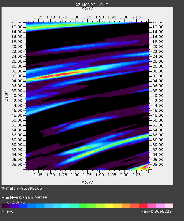
| Estimated Moho Depth: |
68.75 km |
| Estimated Crust Vp/Vs: |
2.10 |
| Assumed Crust Vp: |
6.264 km/s |
| Estimated Crust Vs: |
2.986 km/s |
| Estimated Crust Poisson's Ratio: |
0.35 |
|
| Radial Match: |
95.392105 % |
| Radial Bump: |
400 |
| Transverse Match: |
91.14105 % |
| Transverse Bump: |
400 |
| SOD ConfigId: |
395004 |
| Insert Time: |
2011-12-01 07:39:10.031 +0000 |
| GWidth: |
2.5 |
| Max Bumps: |
400 |
| Tol: |
0.001 |
|
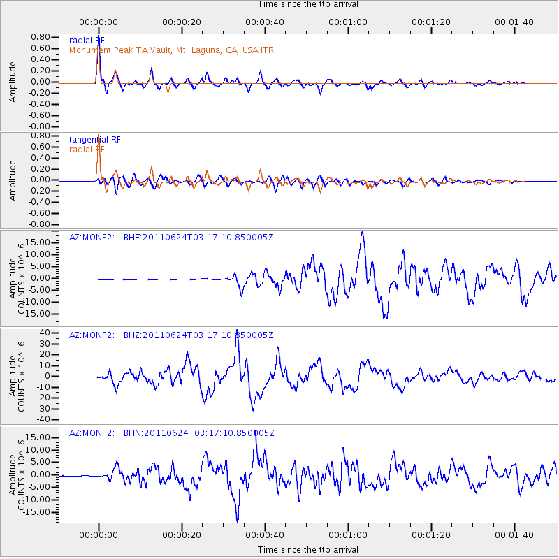
Signal To Noise
| Channel | StoN | STA | LTA |
| AZ:MONP2: :BHZ:20110624T03:17:10.850005Z | 44.099373 | 5.2268474E-6 | 1.185243E-7 |
| AZ:MONP2: :BHN:20110624T03:17:10.850005Z | 24.142944 | 2.249719E-6 | 9.318329E-8 |
| AZ:MONP2: :BHE:20110624T03:17:10.850005Z | 20.560917 | 2.516532E-6 | 1.2239396E-7 |
| Arrivals |
| Ps | 13 SECOND |
| PpPs | 32 SECOND |
| PsPs/PpSs | 45 SECOND |


