You are here: Home > Network List > CI - Caltech Regional Seismic Network Stations List
> Station OSI Osito Adit, California, USA > Earthquake Result Viewer
OSI Osito Adit, California, USA - Earthquake Result Viewer

| Earthquake location: |
Fox Islands, Aleutian Islands |
| Earthquake latitude/longitude: |
52.0/-171.8 |
| Earthquake time(UTC): |
2011/06/24 (175) 03:09:39 GMT |
| Earthquake Depth: |
52 km |
| Earthquake Magnitude: |
6.9 MB, 7.3 MW, 7.3 MW |
| Earthquake Catalog/Contributor: |
WHDF/NEIC |
|
| Network: |
CI Caltech Regional Seismic Network |
| Station: |
OSI Osito Adit, California, USA |
| Lat/Lon: |
34.61 N/118.72 W |
| Elevation: |
706 m |
|
| Distance: |
41.4 deg |
| Az: |
93.486 deg |
| Baz: |
311.638 deg |
| Ray Param: |
0.07369069 |
| Estimated Moho Depth: |
29.0 km |
| Estimated Crust Vp/Vs: |
1.93 |
| Assumed Crust Vp: |
6.1 km/s |
| Estimated Crust Vs: |
3.165 km/s |
| Estimated Crust Poisson's Ratio: |
0.32 |
|
| Radial Match: |
94.420944 % |
| Radial Bump: |
400 |
| Transverse Match: |
78.3693 % |
| Transverse Bump: |
400 |
| SOD ConfigId: |
395004 |
| Insert Time: |
2011-12-01 07:42:38.122 +0000 |
| GWidth: |
2.5 |
| Max Bumps: |
400 |
| Tol: |
0.001 |
|
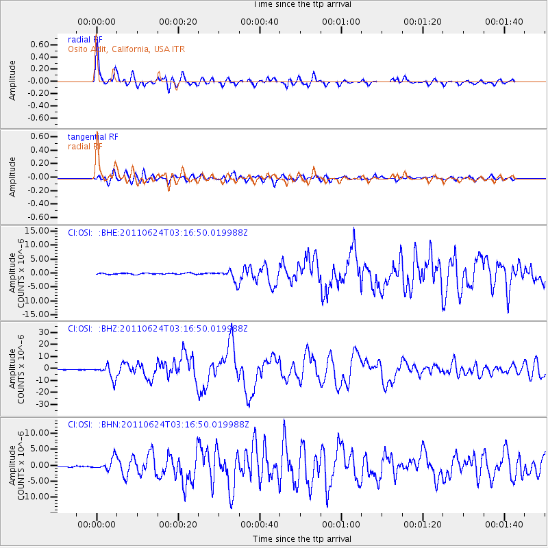
Signal To Noise
| Channel | StoN | STA | LTA |
| CI:OSI: :BHZ:20110624T03:16:50.019988Z | 36.62642 | 5.821605E-6 | 1.5894553E-7 |
| CI:OSI: :BHN:20110624T03:16:50.019988Z | 13.932206 | 1.974334E-6 | 1.4171007E-7 |
| CI:OSI: :BHE:20110624T03:16:50.019988Z | 10.949715 | 2.1863123E-6 | 1.9966842E-7 |
| Arrivals |
| Ps | 4.7 SECOND |
| PpPs | 13 SECOND |
| PsPs/PpSs | 18 SECOND |


