You are here: Home > Network List > CI - Caltech Regional Seismic Network Stations List
> Station IRM Iron Mountain Pumping Station, Eagle Mtn., CA, USA > Earthquake Result Viewer
IRM Iron Mountain Pumping Station, Eagle Mtn., CA, USA - Earthquake Result Viewer
| Earthquake location: |
Fox Islands, Aleutian Islands |
| Earthquake latitude/longitude: |
52.0/-171.8 |
| Earthquake time(UTC): |
2011/06/24 (175) 03:09:39 GMT |
| Earthquake Depth: |
52 km |
| Earthquake Magnitude: |
6.9 MB, 7.3 MW, 7.3 MW |
| Earthquake Catalog/Contributor: |
WHDF/NEIC |
|
| Network: |
CI Caltech Regional Seismic Network |
| Station: |
IRM Iron Mountain Pumping Station, Eagle Mtn., CA, USA |
| Lat/Lon: |
34.16 N/115.15 W |
| Elevation: |
567 m |
|
| Distance: |
43.9 deg |
| Az: |
91.078 deg |
| Baz: |
311.878 deg |
| Ray Param: |
0.07212228 |
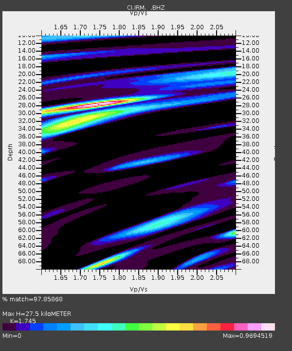
| Estimated Moho Depth: |
27.5 km |
| Estimated Crust Vp/Vs: |
1.75 |
| Assumed Crust Vp: |
6.276 km/s |
| Estimated Crust Vs: |
3.596 km/s |
| Estimated Crust Poisson's Ratio: |
0.26 |
|
| Radial Match: |
97.85868 % |
| Radial Bump: |
369 |
| Transverse Match: |
91.38816 % |
| Transverse Bump: |
400 |
| SOD ConfigId: |
395004 |
| Insert Time: |
2011-12-01 07:46:08.427 +0000 |
| GWidth: |
2.5 |
| Max Bumps: |
400 |
| Tol: |
0.001 |
|

Signal To Noise
| Channel | StoN | STA | LTA |
| CI:IRM: :BHZ:20110624T03:17:10.345Z | 37.769337 | 5.591711E-6 | 1.4804897E-7 |
| CI:IRM: :BHN:20110624T03:17:10.345Z | 19.413769 | 2.143907E-6 | 1.1043229E-7 |
| CI:IRM: :BHE:20110624T03:17:10.345Z | 18.160671 | 2.3292039E-6 | 1.282554E-7 |
| Arrivals |
| Ps | 3.5 SECOND |
| PpPs | 11 SECOND |
| PsPs/PpSs | 15 SECOND |


