You are here: Home > Network List > G - GEOSCOPE Stations List
> Station ATD Arta Cave, Djibouti > Earthquake Result Viewer
ATD Arta Cave, Djibouti - Earthquake Result Viewer
| Earthquake location: |
Hindu Kush Region, Afghanistan |
| Earthquake latitude/longitude: |
36.1/70.7 |
| Earthquake time(UTC): |
2002/01/03 (003) 07:05:27 GMT |
| Earthquake Depth: |
129 km |
| Earthquake Magnitude: |
5.8 MB, 6.2 MW, 6.1 MW |
| Earthquake Catalog/Contributor: |
WHDF/NEIC |
|
| Network: |
G GEOSCOPE |
| Station: |
ATD Arta Cave, Djibouti |
| Lat/Lon: |
11.53 N/42.85 E |
| Elevation: |
610 m |
|
| Distance: |
35.1 deg |
| Az: |
232.803 deg |
| Baz: |
41.172 deg |
| Ray Param: |
0.07698036 |
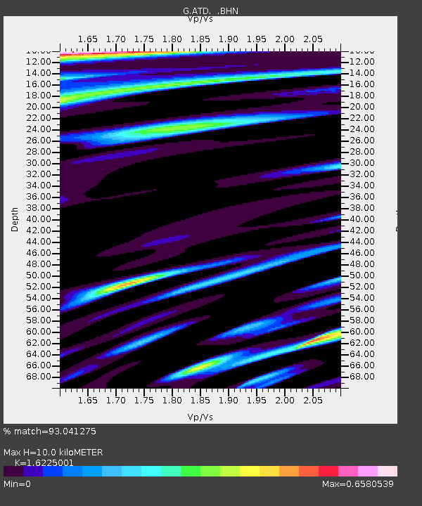
| Estimated Moho Depth: |
10.0 km |
| Estimated Crust Vp/Vs: |
1.62 |
| Assumed Crust Vp: |
6.375 km/s |
| Estimated Crust Vs: |
3.929 km/s |
| Estimated Crust Poisson's Ratio: |
0.19 |
|
| Radial Match: |
93.041275 % |
| Radial Bump: |
400 |
| Transverse Match: |
85.936935 % |
| Transverse Bump: |
400 |
| SOD ConfigId: |
20082 |
| Insert Time: |
2010-02-26 21:26:25.681 +0000 |
| GWidth: |
2.5 |
| Max Bumps: |
400 |
| Tol: |
0.001 |
|
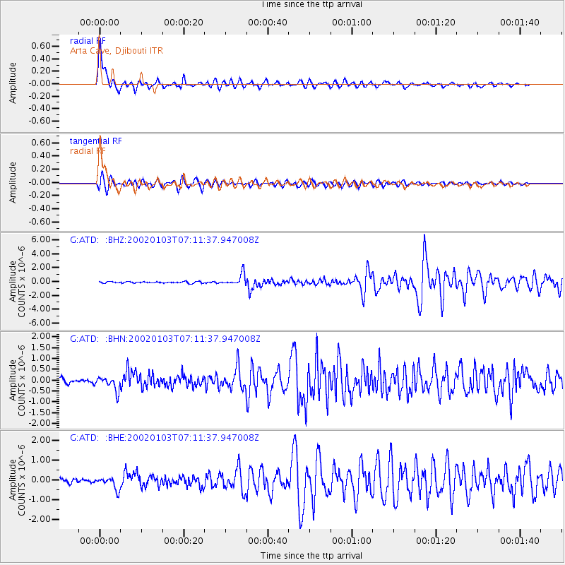
Signal To Noise
| Channel | StoN | STA | LTA |
| G:ATD: :BHN:20020103T07:11:37.947008Z | 2.819548 | 3.0883086E-7 | 1.0953205E-7 |
| G:ATD: :BHE:20020103T07:11:37.947008Z | 3.1889334 | 3.104535E-7 | 9.735339E-8 |
| G:ATD: :BHZ:20020103T07:11:37.947008Z | 8.569536 | 8.516426E-7 | 9.9380244E-8 |
| Arrivals |
| Ps | 1.1 SECOND |
| PpPs | 3.8 SECOND |
| PsPs/PpSs | 4.9 SECOND |


