You are here: Home > Network List > G - GEOSCOPE Stations List
> Station ATD Arta Cave, Djibouti > Earthquake Result Viewer
ATD Arta Cave, Djibouti - Earthquake Result Viewer
| Earthquake location: |
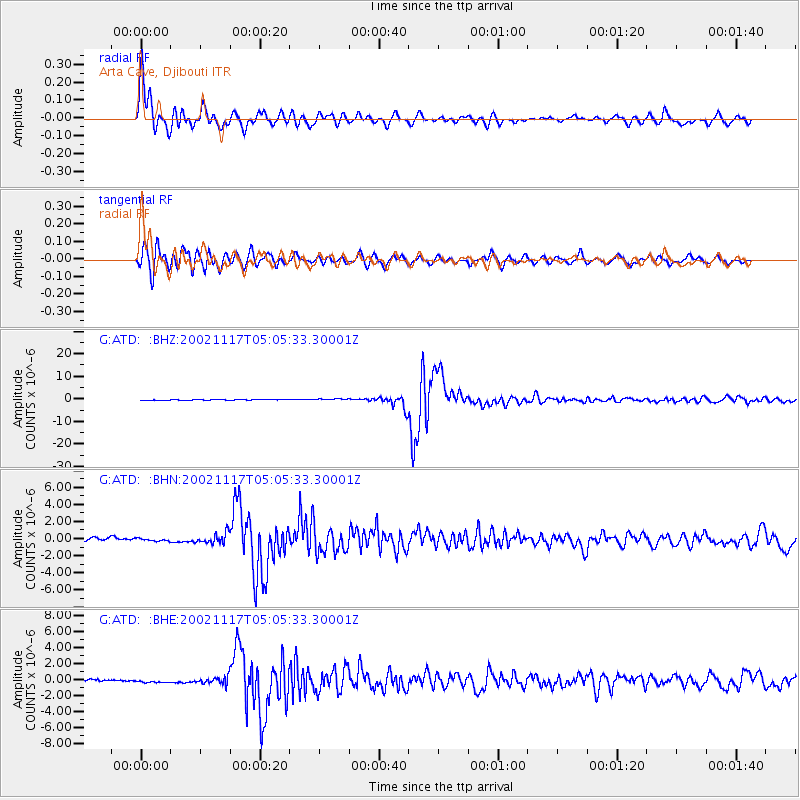
Northwest Of Kuril Islands |
| Earthquake latitude/longitude: |
47.8/146.2 |
| Earthquake time(UTC): |
2002/11/17 (321) 04:53:53 GMT |
| Earthquake Depth: |
459 km |
| Earthquake Magnitude: |
7.3 MW, 7.3 MW |
| Earthquake Catalog/Contributor: |
WHDF/NEIC |
|
| Network: |
G GEOSCOPE |
| Station: |
ATD Arta Cave, Djibouti |
| Lat/Lon: |
11.53 N/42.85 E |
| Elevation: |
610 m |
|
| Distance: |
90.3 deg |
| Az: |
287.529 deg |
| Baz: |
40.969 deg |
| Ray Param: |
0.0415277 |
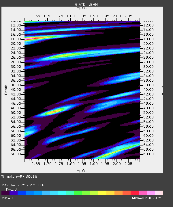
| Estimated Moho Depth: |
17.75 km |
| Estimated Crust Vp/Vs: |
1.60 |
| Assumed Crust Vp: |
6.375 km/s |
| Estimated Crust Vs: |
3.984 km/s |
| Estimated Crust Poisson's Ratio: |
0.18 |
|
| Radial Match: |
97.30618 % |
| Radial Bump: |
400 |
| Transverse Match: |
93.27877 % |
| Transverse Bump: |
400 |
| SOD ConfigId: |
4714 |
| Insert Time: |
2010-02-26 21:26:27.305 +0000 |
| GWidth: |
2.5 |
| Max Bumps: |
400 |
| Tol: |
0.001 |
|
Signal To Noise
| Channel | StoN | STA | LTA |
| G:ATD: :BHN:20021117T05:05:33.30001Z | 0.8732167 | 1.46219E-7 | 1.674487E-7 |
| G:ATD: :BHE:20021117T05:05:33.30001Z | 1.9691399 | 1.954557E-7 | 9.925943E-8 |
| G:ATD: :BHZ:20021117T05:05:33.30001Z | 3.0304525 | 3.718346E-7 | 1.2269936E-7 |
| Arrivals |
| Ps | 1.7 SECOND |
| PpPs | 7.1 SECOND |
| PsPs/PpSs | 8.8 SECOND |


