You are here: Home > Network List > IC - New China Digital Seismograph Network Stations List
> Station LSA Tibet, China > Earthquake Result Viewer
LSA Tibet, China - Earthquake Result Viewer
| Earthquake location: |
Fox Islands, Aleutian Islands |
| Earthquake latitude/longitude: |
52.0/-171.8 |
| Earthquake time(UTC): |
2011/06/24 (175) 03:09:39 GMT |
| Earthquake Depth: |
52 km |
| Earthquake Magnitude: |
6.9 MB, 7.3 MW, 7.3 MW |
| Earthquake Catalog/Contributor: |
WHDF/NEIC |
|
| Network: |
IC New China Digital Seismograph Network |
| Station: |
LSA Tibet, China |
| Lat/Lon: |
29.70 N/91.13 E |
| Elevation: |
3660 m |
|
| Distance: |
71.2 deg |
| Az: |
294.212 deg |
| Baz: |
40.342 deg |
| Ray Param: |
0.054369267 |
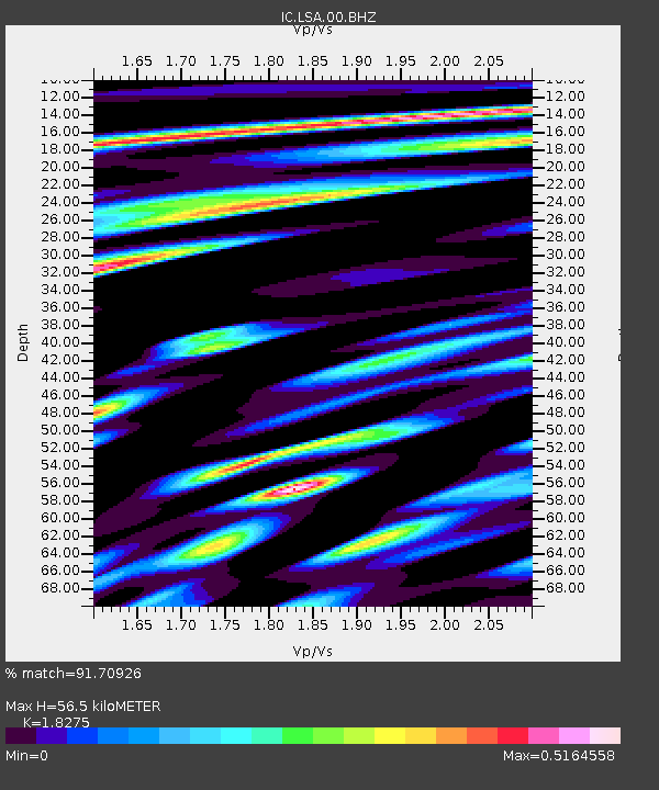
| Estimated Moho Depth: |
56.5 km |
| Estimated Crust Vp/Vs: |
1.83 |
| Assumed Crust Vp: |
6.514 km/s |
| Estimated Crust Vs: |
3.565 km/s |
| Estimated Crust Poisson's Ratio: |
0.29 |
|
| Radial Match: |
91.70926 % |
| Radial Bump: |
400 |
| Transverse Match: |
85.59565 % |
| Transverse Bump: |
400 |
| SOD ConfigId: |
395004 |
| Insert Time: |
2011-12-01 07:50:51.723 +0000 |
| GWidth: |
2.5 |
| Max Bumps: |
400 |
| Tol: |
0.001 |
|

Signal To Noise
| Channel | StoN | STA | LTA |
| IC:LSA:00:BHZ:20110624T03:20:22.199004Z | 46.59427 | 9.971248E-6 | 2.1400159E-7 |
| IC:LSA:00:BHN:20110624T03:20:22.199004Z | 29.638603 | 1.3282033E-6 | 4.481329E-8 |
| IC:LSA:00:BHE:20110624T03:20:22.199004Z | 8.897957 | 2.3989876E-6 | 2.6961106E-7 |
| Arrivals |
| Ps | 7.4 SECOND |
| PpPs | 24 SECOND |
| PsPs/PpSs | 31 SECOND |


