You are here: Home > Network List > IW - Intermountain West Stations List
> Station IMW Indian Meadow, Wyoming, USA > Earthquake Result Viewer
IMW Indian Meadow, Wyoming, USA - Earthquake Result Viewer
| Earthquake location: |
Fox Islands, Aleutian Islands |
| Earthquake latitude/longitude: |
52.0/-171.8 |
| Earthquake time(UTC): |
2011/06/24 (175) 03:09:39 GMT |
| Earthquake Depth: |
52 km |
| Earthquake Magnitude: |
6.9 MB, 7.3 MW, 7.3 MW |
| Earthquake Catalog/Contributor: |
WHDF/NEIC |
|
| Network: |
IW Intermountain West |
| Station: |
IMW Indian Meadow, Wyoming, USA |
| Lat/Lon: |
43.90 N/110.94 W |
| Elevation: |
2646 m |
|
| Distance: |
40.5 deg |
| Az: |
76.63 deg |
| Baz: |
303.789 deg |
| Ray Param: |
0.07423675 |
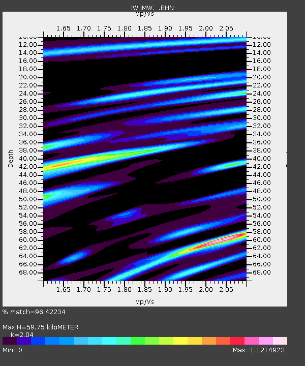
| Estimated Moho Depth: |
59.75 km |
| Estimated Crust Vp/Vs: |
2.04 |
| Assumed Crust Vp: |
6.207 km/s |
| Estimated Crust Vs: |
3.043 km/s |
| Estimated Crust Poisson's Ratio: |
0.34 |
|
| Radial Match: |
96.42234 % |
| Radial Bump: |
400 |
| Transverse Match: |
79.87255 % |
| Transverse Bump: |
400 |
| SOD ConfigId: |
395004 |
| Insert Time: |
2011-12-01 07:52:58.927 +0000 |
| GWidth: |
2.5 |
| Max Bumps: |
400 |
| Tol: |
0.001 |
|
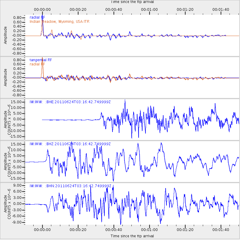
Signal To Noise
| Channel | StoN | STA | LTA |
| IW:IMW: :BHZ:20110624T03:16:42.749999Z | 44.719307 | 4.333579E-6 | 9.690622E-8 |
| IW:IMW: :BHN:20110624T03:16:42.749999Z | 32.543213 | 1.5228222E-6 | 4.679385E-8 |
| IW:IMW: :BHE:20110624T03:16:42.749999Z | 30.707018 | 2.4863311E-6 | 8.096948E-8 |
| Arrivals |
| Ps | 11 SECOND |
| PpPs | 28 SECOND |
| PsPs/PpSs | 38 SECOND |


