You are here: Home > Network List > LD - Lamont-Doherty Cooperative Seismographic Network Stations List
> Station LUPA Lehigh University, PA > Earthquake Result Viewer
LUPA Lehigh University, PA - Earthquake Result Viewer
| Earthquake location: |
Fox Islands, Aleutian Islands |
| Earthquake latitude/longitude: |
52.0/-171.8 |
| Earthquake time(UTC): |
2011/06/24 (175) 03:09:39 GMT |
| Earthquake Depth: |
52 km |
| Earthquake Magnitude: |
6.9 MB, 7.3 MW, 7.3 MW |
| Earthquake Catalog/Contributor: |
WHDF/NEIC |
|
| Network: |
LD Lamont-Doherty Cooperative Seismographic Network |
| Station: |
LUPA Lehigh University, PA |
| Lat/Lon: |
40.60 N/75.37 W |
| Elevation: |
236 m |
|
| Distance: |
62.8 deg |
| Az: |
58.275 deg |
| Baz: |
316.383 deg |
| Ray Param: |
0.059868444 |
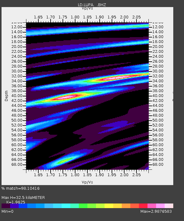
| Estimated Moho Depth: |
32.5 km |
| Estimated Crust Vp/Vs: |
1.96 |
| Assumed Crust Vp: |
6.283 km/s |
| Estimated Crust Vs: |
3.202 km/s |
| Estimated Crust Poisson's Ratio: |
0.32 |
|
| Radial Match: |
98.10416 % |
| Radial Bump: |
343 |
| Transverse Match: |
98.1262 % |
| Transverse Bump: |
351 |
| SOD ConfigId: |
395004 |
| Insert Time: |
2011-12-01 07:57:07.113 +0000 |
| GWidth: |
2.5 |
| Max Bumps: |
400 |
| Tol: |
0.001 |
|

Signal To Noise
| Channel | StoN | STA | LTA |
| LD:LUPA: :BHZ:20110624T03:19:28.94998Z | 76.15314 | 1.4226789E-6 | 1.8681817E-8 |
| LD:LUPA: :BHN:20110624T03:19:28.94998Z | 0.9703912 | 2.2520124E-9 | 2.3207263E-9 |
| LD:LUPA: :BHE:20110624T03:19:28.94998Z | 29.069328 | 2.9879145E-6 | 1.0278581E-7 |
| Arrivals |
| Ps | 5.2 SECOND |
| PpPs | 15 SECOND |
| PsPs/PpSs | 20 SECOND |


