You are here: Home > Network List > TA - USArray Transportable Network (new EarthScope stations) Stations List
> Station J49A Marlette, MI, USA > Earthquake Result Viewer
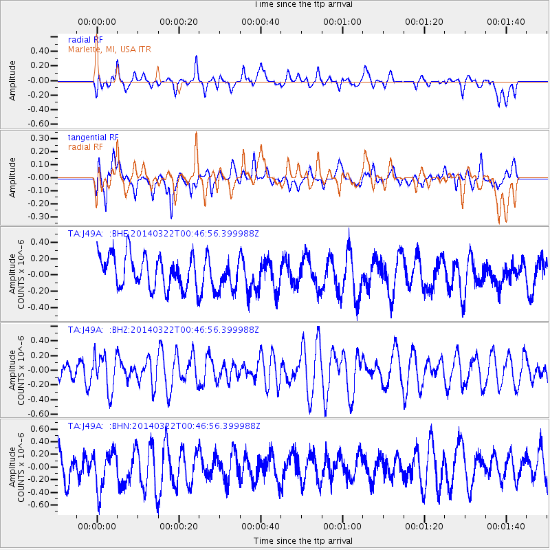
J49A Marlette, MI, USA - Earthquake Result Viewer
*The percent match for this event was below the threshold and hence no stack was calculated.
| Earthquake location: |
Near Coast Of Northern Peru |
| Earthquake latitude/longitude: |
-5.6/-81.0 |
| Earthquake time(UTC): |
2014/03/22 (081) 00:38:45 GMT |
| Earthquake Depth: |
37 km |
| Earthquake Magnitude: |
4.9 mb |
| Earthquake Catalog/Contributor: |
ISC/ISC |
|
| Network: |
TA USArray Transportable Network (new EarthScope stations) |
| Station: |
J49A Marlette, MI, USA |
| Lat/Lon: |
43.36 N/83.14 W |
| Elevation: |
253 m |
|
| Distance: |
48.8 deg |
| Az: |
357.881 deg |
| Baz: |
177.107 deg |
| Ray Param: |
$rayparam |
*The percent match for this event was below the threshold and hence was not used in the summary stack. |
|
| Radial Match: |
39.295776 % |
| Radial Bump: |
400 |
| Transverse Match: |
47.74574 % |
| Transverse Bump: |
400 |
| SOD ConfigId: |
3390531 |
| Insert Time: |
2019-04-10 19:38:53.168 +0000 |
| GWidth: |
2.5 |
| Max Bumps: |
400 |
| Tol: |
0.001 |
|
Signal To Noise
| Channel | StoN | STA | LTA |
| TA:J49A: :BHZ:20140322T00:46:56.399988Z | 1.4416937 | 2.530665E-7 | 1.7553418E-7 |
| TA:J49A: :BHN:20140322T00:46:56.399988Z | 1.4202771 | 3.292172E-7 | 2.3179786E-7 |
| TA:J49A: :BHE:20140322T00:46:56.399988Z | 0.9290467 | 1.86445E-7 | 2.0068421E-7 |
| Arrivals |
| Ps | |
| PpPs | |
| PsPs/PpSs | |


