You are here: Home > Network List > G - GEOSCOPE Stations List
> Station ATD Arta Cave, Djibouti > Earthquake Result Viewer
ATD Arta Cave, Djibouti - Earthquake Result Viewer
| Earthquake location: |
Taiwan Region |
| Earthquake latitude/longitude: |
22.7/121.5 |
| Earthquake time(UTC): |
2004/05/19 (140) 07:04:11 GMT |
| Earthquake Depth: |
20 km |
| Earthquake Magnitude: |
5.8 MB, 6.1 MS, 6.2 MW, 6.1 MW |
| Earthquake Catalog/Contributor: |
WHDF/NEIC |
|
| Network: |
G GEOSCOPE |
| Station: |
ATD Arta Cave, Djibouti |
| Lat/Lon: |
11.53 N/42.85 E |
| Elevation: |
610 m |
|
| Distance: |
75.3 deg |
| Az: |
276.507 deg |
| Baz: |
69.457 deg |
| Ray Param: |
0.051757865 |
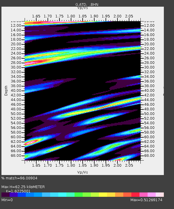
| Estimated Moho Depth: |
62.25 km |
| Estimated Crust Vp/Vs: |
1.62 |
| Assumed Crust Vp: |
6.375 km/s |
| Estimated Crust Vs: |
3.929 km/s |
| Estimated Crust Poisson's Ratio: |
0.19 |
|
| Radial Match: |
96.08904 % |
| Radial Bump: |
400 |
| Transverse Match: |
83.5436 % |
| Transverse Bump: |
400 |
| SOD ConfigId: |
2459 |
| Insert Time: |
2010-02-26 21:26:37.944 +0000 |
| GWidth: |
2.5 |
| Max Bumps: |
400 |
| Tol: |
0.001 |
|
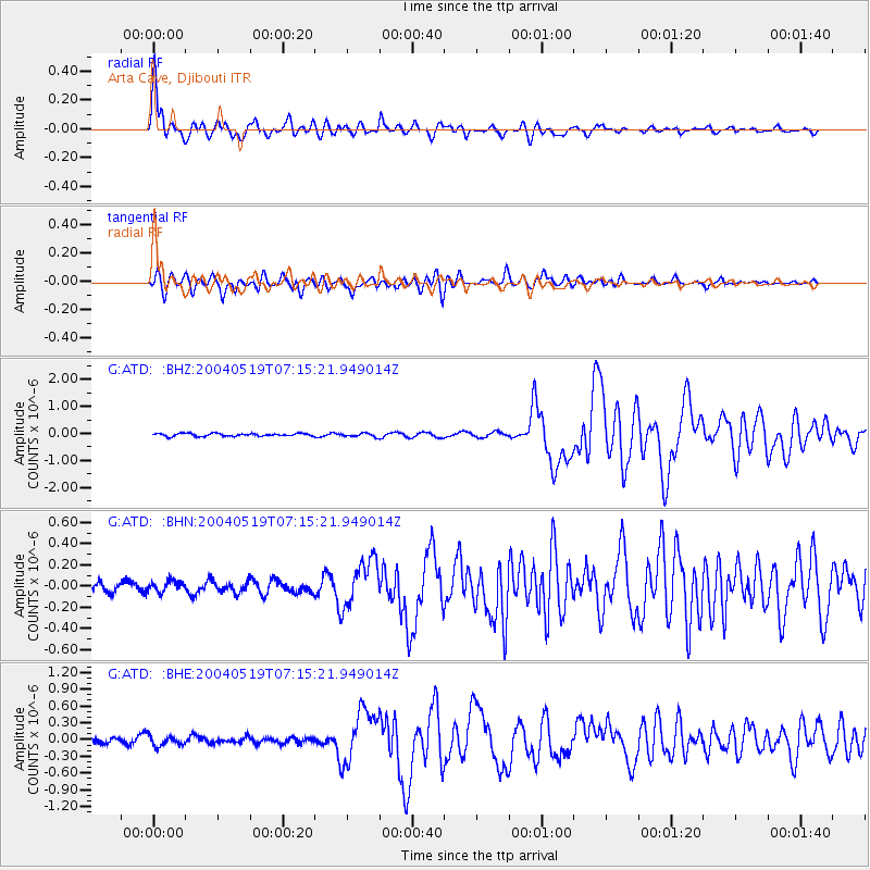
Signal To Noise
| Channel | StoN | STA | LTA |
| G:ATD: :BHN:20040519T07:15:21.949014Z | 0.7037421 | 5.139954E-8 | 7.303746E-8 |
| G:ATD: :BHE:20040519T07:15:21.949014Z | 1.7489651 | 8.992593E-8 | 5.1416652E-8 |
| G:ATD: :BHZ:20040519T07:15:21.949014Z | 1.2870799 | 6.82369E-8 | 5.3016834E-8 |
| Arrivals |
| Ps | 6.3 SECOND |
| PpPs | 25 SECOND |
| PsPs/PpSs | 31 SECOND |


