You are here: Home > Network List > NE - New England Seismic Network Stations List
> Station WES Weston, MA > Earthquake Result Viewer
WES Weston, MA - Earthquake Result Viewer
| Earthquake location: |
Fox Islands, Aleutian Islands |
| Earthquake latitude/longitude: |
52.0/-171.8 |
| Earthquake time(UTC): |
2011/06/24 (175) 03:09:39 GMT |
| Earthquake Depth: |
52 km |
| Earthquake Magnitude: |
6.9 MB, 7.3 MW, 7.3 MW |
| Earthquake Catalog/Contributor: |
WHDF/NEIC |
|
| Network: |
NE New England Seismic Network |
| Station: |
WES Weston, MA |
| Lat/Lon: |
42.38 N/71.32 W |
| Elevation: |
60 m |
|
| Distance: |
63.6 deg |
| Az: |
54.422 deg |
| Baz: |
317.319 deg |
| Ray Param: |
0.05936392 |
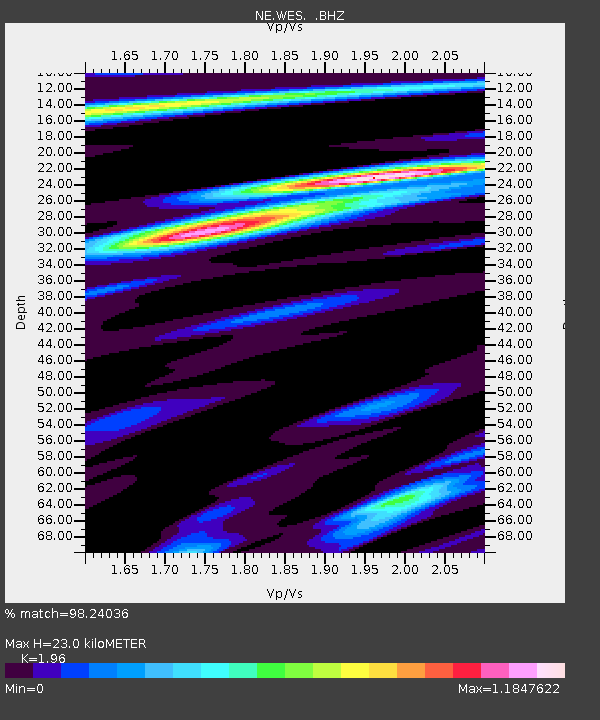
| Estimated Moho Depth: |
23.0 km |
| Estimated Crust Vp/Vs: |
1.96 |
| Assumed Crust Vp: |
6.419 km/s |
| Estimated Crust Vs: |
3.275 km/s |
| Estimated Crust Poisson's Ratio: |
0.32 |
|
| Radial Match: |
98.24036 % |
| Radial Bump: |
400 |
| Transverse Match: |
92.850204 % |
| Transverse Bump: |
400 |
| SOD ConfigId: |
395004 |
| Insert Time: |
2011-12-01 07:59:53.923 +0000 |
| GWidth: |
2.5 |
| Max Bumps: |
400 |
| Tol: |
0.001 |
|

Signal To Noise
| Channel | StoN | STA | LTA |
| NE:WES: :BHZ:20110624T03:19:34.10501Z | 32.720978 | 1.6422697E-5 | 5.019012E-7 |
| NE:WES: :BHN:20110624T03:19:34.10501Z | 13.330041 | 4.8124584E-6 | 3.610235E-7 |
| NE:WES: :BHE:20110624T03:19:34.10501Z | 13.834911 | 4.5278107E-6 | 3.2727428E-7 |
| Arrivals |
| Ps | 3.6 SECOND |
| PpPs | 10 SECOND |
| PsPs/PpSs | 14 SECOND |


