You are here: Home > Network List > NE - New England Seismic Network Stations List
> Station HNH Hanover, NH > Earthquake Result Viewer
HNH Hanover, NH - Earthquake Result Viewer
| Earthquake location: |
Fox Islands, Aleutian Islands |
| Earthquake latitude/longitude: |
52.0/-171.8 |
| Earthquake time(UTC): |
2011/06/24 (175) 03:09:39 GMT |
| Earthquake Depth: |
52 km |
| Earthquake Magnitude: |
6.9 MB, 7.3 MW, 7.3 MW |
| Earthquake Catalog/Contributor: |
WHDF/NEIC |
|
| Network: |
NE New England Seismic Network |
| Station: |
HNH Hanover, NH |
| Lat/Lon: |
43.71 N/72.29 W |
| Elevation: |
180 m |
|
| Distance: |
62.1 deg |
| Az: |
53.989 deg |
| Baz: |
316.465 deg |
| Ray Param: |
0.06030294 |
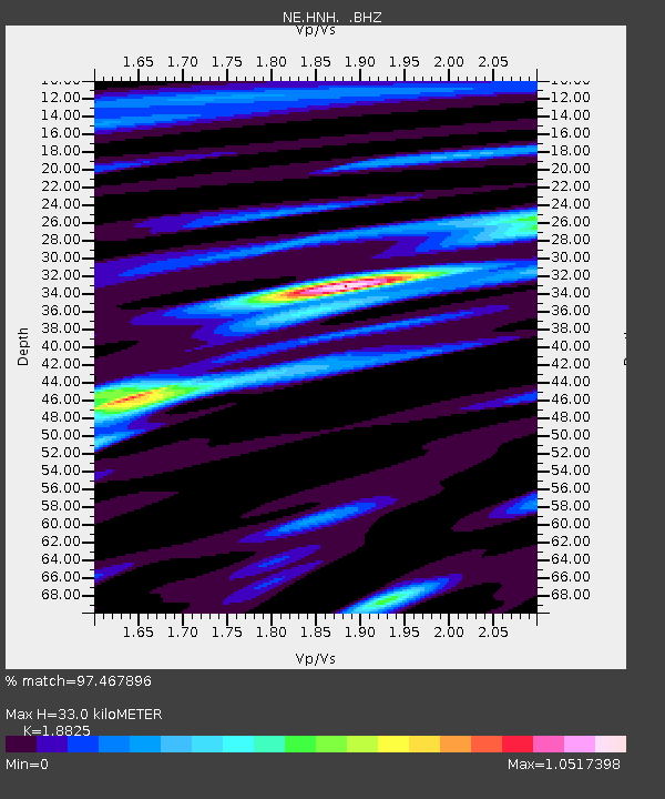
| Estimated Moho Depth: |
33.0 km |
| Estimated Crust Vp/Vs: |
1.88 |
| Assumed Crust Vp: |
6.419 km/s |
| Estimated Crust Vs: |
3.41 km/s |
| Estimated Crust Poisson's Ratio: |
0.30 |
|
| Radial Match: |
97.467896 % |
| Radial Bump: |
364 |
| Transverse Match: |
91.65659 % |
| Transverse Bump: |
400 |
| SOD ConfigId: |
395004 |
| Insert Time: |
2011-12-01 08:00:09.197 +0000 |
| GWidth: |
2.5 |
| Max Bumps: |
400 |
| Tol: |
0.001 |
|

Signal To Noise
| Channel | StoN | STA | LTA |
| NE:HNH: :BHZ:20110624T03:19:24.495024Z | 30.3576 | 1.4626615E-5 | 4.818106E-7 |
| NE:HNH: :BHN:20110624T03:19:24.495024Z | 17.326826 | 5.180539E-6 | 2.989895E-7 |
| NE:HNH: :BHE:20110624T03:19:24.495024Z | 14.969667 | 5.438461E-6 | 3.632987E-7 |
| Arrivals |
| Ps | 4.7 SECOND |
| PpPs | 14 SECOND |
| PsPs/PpSs | 19 SECOND |


