You are here: Home > Network List > TA - USArray Transportable Network (new EarthScope stations) Stations List
> Station E29A Napoleon, ND, USA > Earthquake Result Viewer
E29A Napoleon, ND, USA - Earthquake Result Viewer

| Earthquake location: |
Fox Islands, Aleutian Islands |
| Earthquake latitude/longitude: |
52.0/-171.8 |
| Earthquake time(UTC): |
2011/06/24 (175) 03:09:39 GMT |
| Earthquake Depth: |
52 km |
| Earthquake Magnitude: |
6.9 MB, 7.3 MW, 7.3 MW |
| Earthquake Catalog/Contributor: |
WHDF/NEIC |
|
| Network: |
TA USArray Transportable Network (new EarthScope stations) |
| Station: |
E29A Napoleon, ND, USA |
| Lat/Lon: |
46.57 N/99.64 W |
| Elevation: |
628 m |
|
| Distance: |
45.6 deg |
| Az: |
66.833 deg |
| Baz: |
304.623 deg |
| Ray Param: |
0.07102645 |
| Estimated Moho Depth: |
16.25 km |
| Estimated Crust Vp/Vs: |
1.60 |
| Assumed Crust Vp: |
6.53 km/s |
| Estimated Crust Vs: |
4.082 km/s |
| Estimated Crust Poisson's Ratio: |
0.18 |
|
| Radial Match: |
97.6859 % |
| Radial Bump: |
274 |
| Transverse Match: |
90.53761 % |
| Transverse Bump: |
400 |
| SOD ConfigId: |
395004 |
| Insert Time: |
2011-12-01 08:08:56.571 +0000 |
| GWidth: |
2.5 |
| Max Bumps: |
400 |
| Tol: |
0.001 |
|
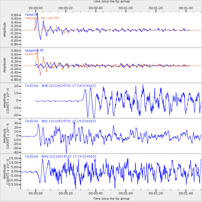
Signal To Noise
| Channel | StoN | STA | LTA |
| TA:E29A: :BHZ:20110624T03:17:24.024993Z | 95.24549 | 1.4417079E-5 | 1.5136757E-7 |
| TA:E29A: :BHN:20110624T03:17:24.024993Z | 19.192602 | 6.9112452E-6 | 3.6009942E-7 |
| TA:E29A: :BHE:20110624T03:17:24.024993Z | 21.782166 | 9.451719E-6 | 4.3392006E-7 |
| Arrivals |
| Ps | 1.6 SECOND |
| PpPs | 6.0 SECOND |
| PsPs/PpSs | 7.6 SECOND |


