You are here: Home > Network List > TA - USArray Transportable Network (new EarthScope stations) Stations List
> Station I30A Oacoma, SD, USA > Earthquake Result Viewer
I30A Oacoma, SD, USA - Earthquake Result Viewer

| Earthquake location: |
Fox Islands, Aleutian Islands |
| Earthquake latitude/longitude: |
52.0/-171.8 |
| Earthquake time(UTC): |
2011/06/24 (175) 03:09:39 GMT |
| Earthquake Depth: |
52 km |
| Earthquake Magnitude: |
6.9 MB, 7.3 MW, 7.3 MW |
| Earthquake Catalog/Contributor: |
WHDF/NEIC |
|
| Network: |
TA USArray Transportable Network (new EarthScope stations) |
| Station: |
I30A Oacoma, SD, USA |
| Lat/Lon: |
43.91 N/99.43 W |
| Elevation: |
549 m |
|
| Distance: |
47.3 deg |
| Az: |
69.685 deg |
| Baz: |
306.742 deg |
| Ray Param: |
0.069955796 |
| Estimated Moho Depth: |
28.5 km |
| Estimated Crust Vp/Vs: |
2.10 |
| Assumed Crust Vp: |
6.53 km/s |
| Estimated Crust Vs: |
3.113 km/s |
| Estimated Crust Poisson's Ratio: |
0.35 |
|
| Radial Match: |
96.30946 % |
| Radial Bump: |
382 |
| Transverse Match: |
88.45527 % |
| Transverse Bump: |
400 |
| SOD ConfigId: |
395004 |
| Insert Time: |
2011-12-01 08:11:06.388 +0000 |
| GWidth: |
2.5 |
| Max Bumps: |
400 |
| Tol: |
0.001 |
|
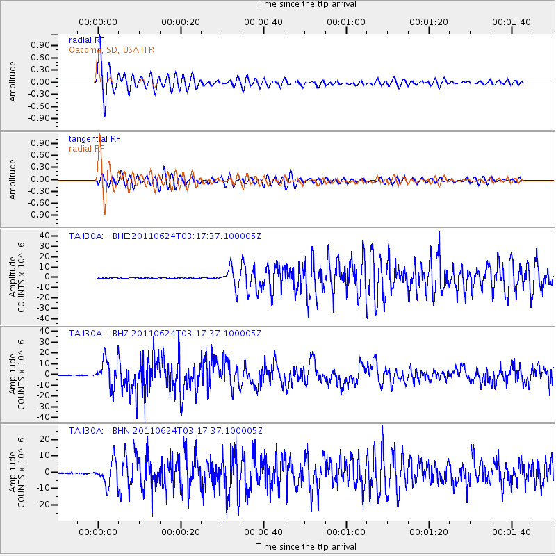
Signal To Noise
| Channel | StoN | STA | LTA |
| TA:I30A: :BHZ:20110624T03:17:37.100005Z | 76.60043 | 1.2941351E-5 | 1.6894617E-7 |
| TA:I30A: :BHN:20110624T03:17:37.100005Z | 36.48557 | 7.533047E-6 | 2.064665E-7 |
| TA:I30A: :BHE:20110624T03:17:37.100005Z | 44.004307 | 9.798414E-6 | 2.2266943E-7 |
| Arrivals |
| Ps | 5.1 SECOND |
| PpPs | 13 SECOND |
| PsPs/PpSs | 18 SECOND |


