You are here: Home > Network List > TA - USArray Transportable Network (new EarthScope stations) Stations List
> Station S32A Newby Ranch, Pratt, KS, USA > Earthquake Result Viewer
S32A Newby Ranch, Pratt, KS, USA - Earthquake Result Viewer

| Earthquake location: |
Fox Islands, Aleutian Islands |
| Earthquake latitude/longitude: |
52.0/-171.8 |
| Earthquake time(UTC): |
2011/06/24 (175) 03:09:39 GMT |
| Earthquake Depth: |
52 km |
| Earthquake Magnitude: |
6.9 MB, 7.3 MW, 7.3 MW |
| Earthquake Catalog/Contributor: |
WHDF/NEIC |
|
| Network: |
TA USArray Transportable Network (new EarthScope stations) |
| Station: |
S32A Newby Ranch, Pratt, KS, USA |
| Lat/Lon: |
37.70 N/98.94 W |
| Elevation: |
558 m |
|
| Distance: |
51.5 deg |
| Az: |
75.746 deg |
| Baz: |
311.012 deg |
| Ray Param: |
0.06726311 |
| Estimated Moho Depth: |
65.0 km |
| Estimated Crust Vp/Vs: |
1.94 |
| Assumed Crust Vp: |
6.426 km/s |
| Estimated Crust Vs: |
3.312 km/s |
| Estimated Crust Poisson's Ratio: |
0.32 |
|
| Radial Match: |
97.03706 % |
| Radial Bump: |
329 |
| Transverse Match: |
86.53987 % |
| Transverse Bump: |
400 |
| SOD ConfigId: |
395004 |
| Insert Time: |
2011-12-01 08:11:39.161 +0000 |
| GWidth: |
2.5 |
| Max Bumps: |
400 |
| Tol: |
0.001 |
|
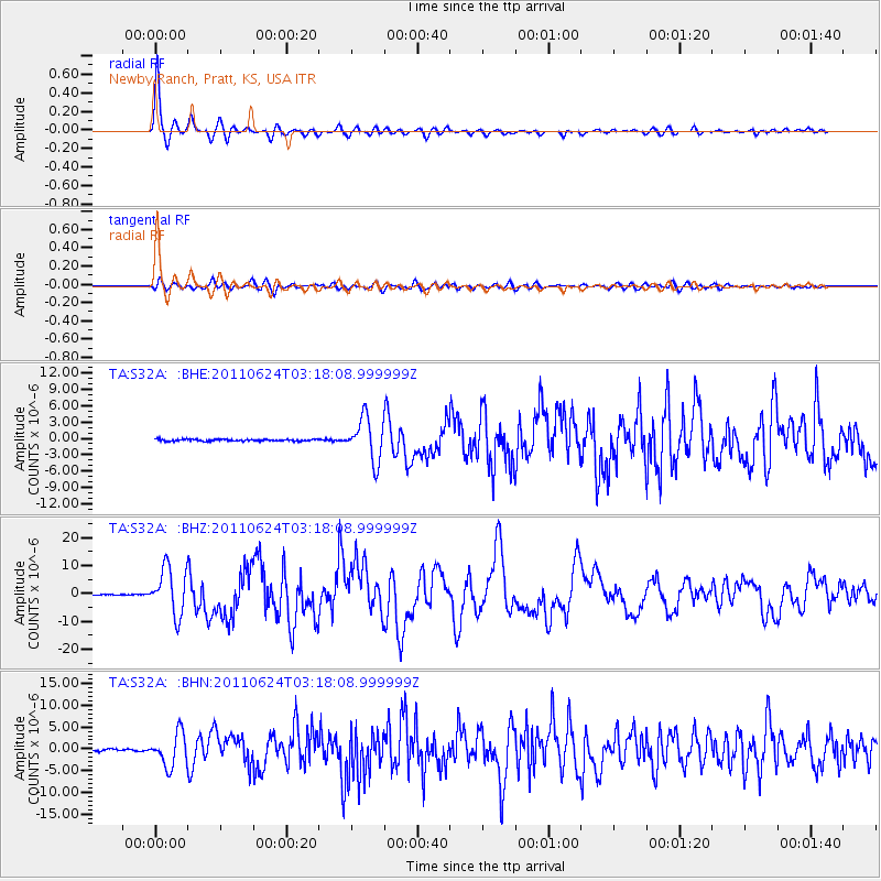
Signal To Noise
| Channel | StoN | STA | LTA |
| TA:S32A: :BHZ:20110624T03:18:08.999999Z | 72.76064 | 8.295058E-6 | 1.1400474E-7 |
| TA:S32A: :BHN:20110624T03:18:08.999999Z | 20.128996 | 3.767253E-6 | 1.8715554E-7 |
| TA:S32A: :BHE:20110624T03:18:08.999999Z | 22.495945 | 3.9085594E-6 | 1.7374505E-7 |
| Arrivals |
| Ps | 10 SECOND |
| PpPs | 28 SECOND |
| PsPs/PpSs | 38 SECOND |


