You are here: Home > Network List > TA - USArray Transportable Network (new EarthScope stations) Stations List
> Station K04D Chiloquin, OR, USA > Earthquake Result Viewer
K04D Chiloquin, OR, USA - Earthquake Result Viewer
| Earthquake location: |
Fox Islands, Aleutian Islands |
| Earthquake latitude/longitude: |
52.0/-171.8 |
| Earthquake time(UTC): |
2011/06/24 (175) 03:09:39 GMT |
| Earthquake Depth: |
52 km |
| Earthquake Magnitude: |
6.9 MB, 7.3 MW, 7.3 MW |
| Earthquake Catalog/Contributor: |
WHDF/NEIC |
|
| Network: |
TA USArray Transportable Network (new EarthScope stations) |
| Station: |
K04D Chiloquin, OR, USA |
| Lat/Lon: |
42.62 N/121.75 W |
| Elevation: |
1315 m |
|
| Distance: |
34.6 deg |
| Az: |
85.539 deg |
| Baz: |
303.471 deg |
| Ray Param: |
0.07753084 |
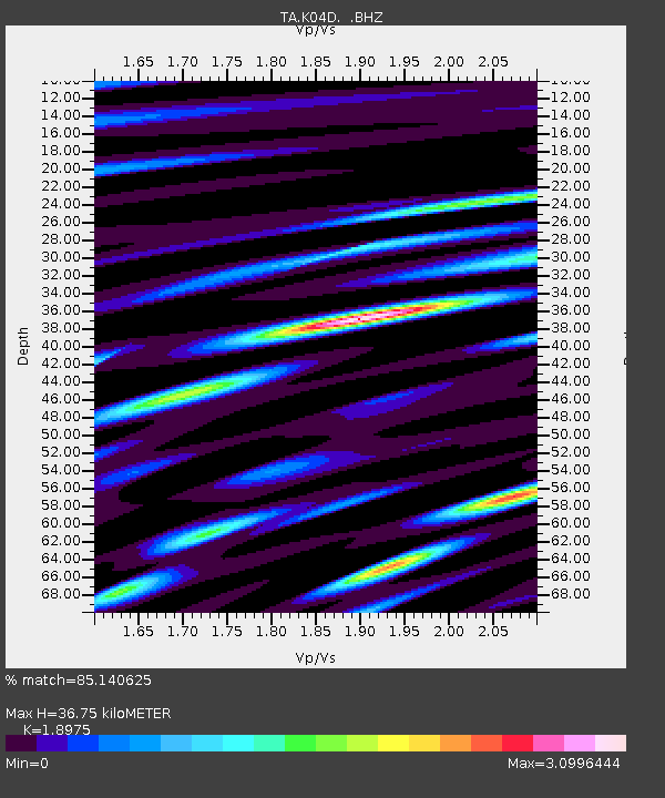
| Estimated Moho Depth: |
36.75 km |
| Estimated Crust Vp/Vs: |
1.90 |
| Assumed Crust Vp: |
6.597 km/s |
| Estimated Crust Vs: |
3.477 km/s |
| Estimated Crust Poisson's Ratio: |
0.31 |
|
| Radial Match: |
85.140625 % |
| Radial Bump: |
400 |
| Transverse Match: |
76.39708 % |
| Transverse Bump: |
400 |
| SOD ConfigId: |
395004 |
| Insert Time: |
2011-12-01 08:11:54.017 +0000 |
| GWidth: |
2.5 |
| Max Bumps: |
400 |
| Tol: |
0.001 |
|
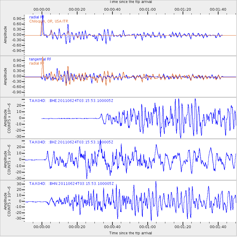
Signal To Noise
| Channel | StoN | STA | LTA |
| TA:K04D: :BHZ:20110624T03:15:53.100005Z | 35.336044 | 5.558513E-6 | 1.5730434E-7 |
| TA:K04D: :BHN:20110624T03:15:53.100005Z | 7.0582337 | 1.7244236E-6 | 2.4431375E-7 |
| TA:K04D: :BHE:20110624T03:15:53.100005Z | 13.892001 | 2.4851338E-6 | 1.7888955E-7 |
| Arrivals |
| Ps | 5.4 SECOND |
| PpPs | 15 SECOND |
| PsPs/PpSs | 20 SECOND |


